Belford geodata
Belford (England) is a seat of a third-order administrative division; located in United Kingdom in Europe/London (GMT+1) time zone. With population of 1,258 people, there are 3289 cities with bigger population in this country. Compared to other cities in United Kingdom, 89.3% of cities are located further ↓South; 51.7% of cities are located further →East and 53% of cities have higher elevation than Belford. Note1


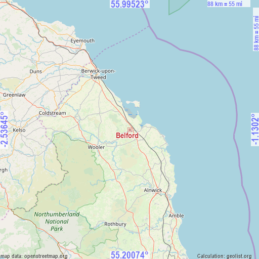
Belford GPS coordinates[2]
55° 36' 0" North, 1° 49' 59.988" West
| Map corner | latitude | longitude |
|---|---|---|
| Upper-left | 55.99523°, | -2.53645° |
| Center: | 55.6°, | -1.83333° |
| Lower-right: | 55.20074°, | -1.1302° |
| Map W x H: | 88.3×88.3 km | = 54.9×54.9mi |
| max Lat: | 60.39635° ⇑10.7% North |
| Belford: | 55.6° |
| min Lat: | ⇓89.3% South 34.60088° |
| min Long | Belford | max Long |
| -7.64133° | -1.83333° | 32.95536° |
| W 48.3%⇐ | ⇒51.7% E |
Elevation
Elevation of Belford is 56 m = 184 ft, and this is 16.9 m = 55 ft below average elevation for this country.
| Max E: |
515 m = 1690 ft | 53% |
| Avg. | 72.9 m = 239 ft | |
| Belford | 56 m = 184 ft | |
Min E: |
-30 m = -98 ft | 47% |
See also: United Kingdom elevation on elevation.city.
Geographical zone
Belford is located in North temperate zone (between Tropic of Cancer and the Arctic Circle). Distance of this North polar circle is 1219 km =757.5 mi to North.| Distance of | km | miles | from Belford |
|---|---|---|---|
| North Pole | 3824.9 | 2376.7 | to North |
| Arctic Circle | 1219 | 757.5 | to North |
| Tropic Cancer | 3576.2 | 2222.1 | to South |
| Equator | 6182.1 | 3841.4 | to South |


Nearby cities:
15 places around Belford: (largest is in red/bold)
• Alnwick
22.3 km =13.9 mi,  158°
158°
• Ancroft
15.3 km =9.5 mi,  316°
316°
• Bamburgh
7.3 km =4.5 mi,  84°
84°
• Beadnell
13.5 km =8.4 mi,  110°
110°
• Berwick-Upon-Tweed
21.5 km =13.4 mi,  328°
328°
• Doddington
10.9 km =6.8 mi,  261°
261°
• Ellingham
10.3 km =6.4 mi,  143°
143°
• Embleton
17 km =10.6 mi,  133°
133°
• Ford
16.1 km =10 mi,  283°
283°
• Kirknewton
19.7 km =12.2 mi,  253°
253°
• Lowick
10.7 km =6.6 mi,  301°
301°
• North Sunderland
10.9 km =6.8 mi,  103°
103°
• Seahouses
11.4 km =7.1 mi, 100°
• Whittingham
22.4 km =13.9 mi,  189°
189°
• Wooler
12.6 km =7.8 mi,  242°
242°
Sources, notices
• [Note1] Compared only with cities in United Kingdom existing in our database
• [Src1] Map data: © OpenStreetMap contributors (CC-BY-SA)
• [Src2] Other city data from geonames.org with taken over terms of usage.
• [Src3] Geographical zone / Annual Mean Temperature by Robert A. Rohde @ Wikipedia
