Beckenham geodata
Beckenham (England) is a populated place; located in United Kingdom in Europe/London (GMT+1) time zone. With population of 82,000 people, there are 124 cities with bigger population in this country. Compared to other cities in United Kingdom, 80.6% of cities are located further ↑North; 86% of cities are located further ←West and 61% of cities have higher elevation than Beckenham. Note1


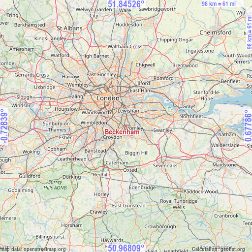
Beckenham GPS coordinates[2]
51° 24' 31.608" North, 0° 1' 30.936" West
| Map corner | latitude | longitude |
|---|---|---|
| Upper-left | 51.84526°, | -0.72839° |
| Center: | 51.40878°, | -0.02526° |
| Lower-right: | 50.96809°, | 0.67786° |
| Map W x H: | 97.5×97.5 km | = 60.6×60.6mi |
| max Lat: | 60.39635° ⇑80.6% North |
| Beckenham: | 51.40878° |
| min Lat: | ⇓19.4% South 34.60088° |
| min Long | Beckenham | max Long |
| -7.64133° | -0.02526° | 32.95536° |
| W 86%⇐ | ⇒14% E |
Elevation
Elevation of Beckenham is 45 m = 148 ft, and this is 27.9 m = 92 ft below average elevation for this country.
| Max E: |
515 m = 1690 ft | 61% |
| Avg. | 72.9 m = 239 ft | |
| Beckenham | 45 m = 148 ft | |
Min E: |
-30 m = -98 ft | 39% |
See also: Beckenham elevation on elevation.city.
Geographical zone
Beckenham is located in North temperate zone (between Tropic of Cancer and the Arctic Circle). Distance of this North polar circle is 1685.1 km =1047.1 mi to North.| Distance of | km | miles | from Beckenham |
|---|---|---|---|
| North Pole | 4290.9 | 2666.2 | to North |
| Arctic Circle | 1685.1 | 1047.1 | to North |
| Tropic Cancer | 3110.2 | 1932.6 | to South |
| Equator | 5716.1 | 3551.8 | to South |


Nearby cities:
15 places around Beckenham: (largest is in red/bold)
• Blackheath
6.6 km =4.1 mi,  20°
20°
• Brixton
8.5 km =5.3 mi,  318°
318°
• Brixton Hill
8.3 km =5.2 mi,  305°
305°
• Bromley
2.8 km =1.7 mi,  96°
96°
• Camberwell
8.7 km =5.4 mi,  326°
326°
• Catford
4 km =2.5 mi,  4°
4°
• Chislehurst
6.6 km =4.1 mi,  81°
81°
• Croydon
5.9 km =3.7 mi,  241°
241°
• Farnborough
8.5 km =5.3 mi,  129°
129°
• Peckham
7.9 km =4.9 mi,  337°
337°
• Shortlands
2.3 km =1.4 mi,  117°
117°
• Sidcup
9.1 km =5.7 mi, 77°
• South Croydon
7.1 km =4.4 mi,  222°
222°
• Thornton Heath
5.2 km =3.2 mi,  257°
257°
• West Wickham
4.7 km =2.9 mi,  172°
172°
Sources, notices
• [Note1] Compared only with cities in United Kingdom existing in our database
• [Src1] Map data: © OpenStreetMap contributors (CC-BY-SA)
• [Src2] Other city data from geonames.org with taken over terms of usage.
• [Src3] Geographical zone / Annual Mean Temperature by Robert A. Rohde @ Wikipedia
