Croydon geodata
Croydon (England) is a seat of a third-order administrative division; located in United Kingdom in Europe/London (GMT+1) time zone. With population of 173,314 people, there are 47 cities with bigger population in this country. Compared to other cities in United Kingdom, 81.5% of cities are located further ↑North; 84.9% of cities are located further ←West and 54.4% of cities have higher elevation than Croydon. Note1


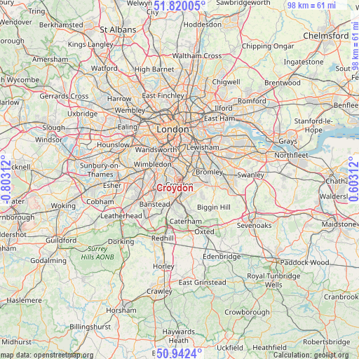
Croydon GPS coordinates[2]
51° 22' 59.988" North, 0° 6' 0" West
| Map corner | latitude | longitude |
|---|---|---|
| Upper-left | 51.82005°, | -0.80312° |
| Center: | 51.38333°, | -0.1° |
| Lower-right: | 50.9424°, | 0.60312° |
| Map W x H: | 97.6×97.6 km | = 60.6×60.6mi |
| max Lat: | 60.39635° ⇑81.5% North |
| Croydon: | 51.38333° |
| min Lat: | ⇓18.5% South 34.60088° |
| min Long | Croydon | max Long |
| -7.64133° | -0.1° | 32.95536° |
| W 84.9%⇐ | ⇒15.1% E |
Elevation
Elevation of Croydon is 54 m = 177 ft, and this is 18.9 m = 62 ft below average elevation for this country.
| Max E: |
515 m = 1690 ft | 54.4% |
| Avg. | 72.9 m = 239 ft | |
| Croydon | 54 m = 177 ft | |
Min E: |
-30 m = -98 ft | 45.6% |
See also: Croydon elevation on elevation.city.
Geographical zone
Croydon is located in North temperate zone (between Tropic of Cancer and the Arctic Circle). Distance of this North polar circle is 1687.9 km =1048.8 mi to North.| Distance of | km | miles | from Croydon |
|---|---|---|---|
| North Pole | 4293.8 | 2668 | to North |
| Arctic Circle | 1687.9 | 1048.8 | to North |
| Tropic Cancer | 3107.4 | 1930.8 | to South |
| Equator | 5713.3 | 3550.1 | to South |


Nearby cities:
15 places around Croydon: (largest is in red/bold)
• Beckenham
5.9 km =3.7 mi,  61°
61°
• Brixton Hill
7.8 km =4.8 mi,  348°
348°
• Bromley
8.4 km =5.2 mi,  72°
72°
• Carshalton
5 km =3.1 mi,  250°
250°
• Coulsdon
7.6 km =4.7 mi,  201°
201°
• Mitcham
5.2 km =3.2 mi,  295°
295°
• Morden
7 km =4.3 mi,  283°
283°
• Purley
5.2 km =3.2 mi,  189°
189°
• Shortlands
7.5 km =4.7 mi,  76°
76°
• South Croydon
2.4 km =1.5 mi,  170°
170°
• Sutton
7.9 km =4.9 mi,  241°
241°
• Thornton Heath
1.7 km =1.1 mi,  2°
2°
• Warlingham
8.7 km =5.4 mi,  160°
160°
• West Wickham
6.1 km =3.8 mi,  107°
107°
• Whyteleafe
8.4 km =5.2 mi, 172°
Sources, notices
• [Note1] Compared only with cities in United Kingdom existing in our database
• [Src1] Map data: © OpenStreetMap contributors (CC-BY-SA)
• [Src2] Other city data from geonames.org with taken over terms of usage.
• [Src3] Geographical zone / Annual Mean Temperature by Robert A. Rohde @ Wikipedia
