Batley geodata
Batley (England) is a populated place; located in United Kingdom in Europe/London (GMT+1) time zone. With population of 50,807 people, there are 228 cities with bigger population in this country. Compared to other cities in United Kingdom, 73.8% of cities are located further ↓South; 52.3% of cities are located further ←West and 51.7% of cities have higher elevation than Batley. Note1


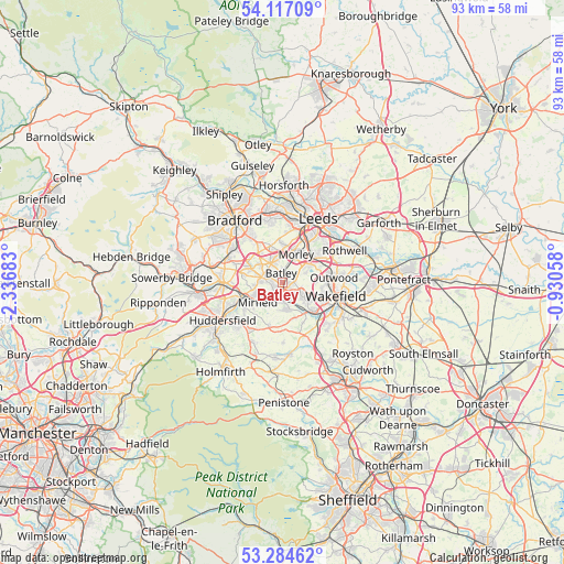
Batley GPS coordinates[2]
53° 42' 10.476" North, 1° 38' 1.32" West
| Map corner | latitude | longitude |
|---|---|---|
| Upper-left | 54.11709°, | -2.33683° |
| Center: | 53.70291°, | -1.6337° |
| Lower-right: | 53.28462°, | -0.93058° |
| Map W x H: | 92.6×92.6 km | = 57.5×57.5mi |
| max Lat: | 60.39635° ⇑26.2% North |
| Batley: | 53.70291° |
| min Lat: | ⇓73.8% South 34.60088° |
| min Long | Batley | max Long |
| -7.64133° | -1.6337° | 32.95536° |
| W 52.3%⇐ | ⇒47.7% E |
Elevation
Elevation of Batley is 58 m = 190 ft, and this is 14.9 m = 49 ft below average elevation for this country.
| Max E: |
515 m = 1690 ft | 51.7% |
| Avg. | 72.9 m = 239 ft | |
| Batley | 58 m = 190 ft | |
Min E: |
-30 m = -98 ft | 48.3% |
See also: Batley elevation on elevation.city.
Geographical zone
Batley is located in North temperate zone (between Tropic of Cancer and the Arctic Circle). Distance of this North polar circle is 1430 km =888.6 mi to North.| Distance of | km | miles | from Batley |
|---|---|---|---|
| North Pole | 4035.9 | 2507.8 | to North |
| Arctic Circle | 1430 | 888.6 | to North |
| Tropic Cancer | 3365.3 | 2091.1 | to South |
| Equator | 5971.2 | 3710.3 | to South |


Nearby cities:
15 places around Batley: (largest is in red/bold)
• Cleckheaton
5.7 km =3.5 mi,  294°
294°
• Dewsbury
1.4 km =0.9 mi,  167°
167°
• Drighlington
6.2 km =3.9 mi,  341°
341°
• Flockton
8.1 km =5 mi,  182°
182°
• Gildersome
6.5 km =4 mi,  1°
1°
• Heckmondwike
2.9 km =1.8 mi,  277°
277°
• Horbury
6.8 km =4.2 mi,  134°
134°
• Kirkhamgate
5.3 km =3.3 mi,  91°
91°
• Liversedge
3.9 km =2.4 mi,  273°
273°
• Lofthouse
9.5 km =5.9 mi,  71°
71°
• Middlestown
6.3 km =3.9 mi,  157°
157°
• Mirfield
5.3 km =3.3 mi,  231°
231°
• Morley
4.7 km =2.9 mi,  29°
29°
• Ossett
4.4 km =2.7 mi, 126°
• Wakefield
9.2 km =5.7 mi,  103°
103°
Sources, notices
• [Note1] Compared only with cities in United Kingdom existing in our database
• [Src1] Map data: © OpenStreetMap contributors (CC-BY-SA)
• [Src2] Other city data from geonames.org with taken over terms of usage.
• [Src3] Geographical zone / Annual Mean Temperature by Robert A. Rohde @ Wikipedia
