Andoversford geodata
Andoversford (England) is a populated place; located in United Kingdom in Europe/London (GMT+1) time zone. With population of 555 people, there are 4719 cities with bigger population in this country. Compared to other cities in United Kingdom, 65.6% of cities are located further ↑North; 54.1% of cities are located further →East and 93.2% of cities have lower elevation than Andoversford. Note1
Administrative division(s):
- Level 1: England
- Level 2: Gloucestershire
- Level 3: Cotswold District
- Level 4: Andoversford


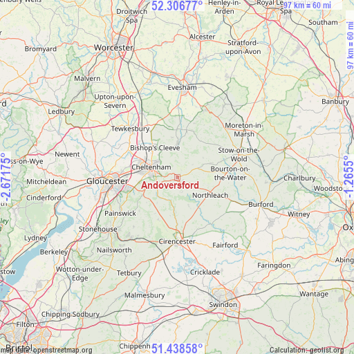
Andoversford GPS coordinates[2]
51° 52' 29.172" North, 1° 58' 7.068" West
| Map corner | latitude | longitude |
|---|---|---|
| Upper-left | 52.30677°, | -2.67175° |
| Center: | 51.87477°, | -1.96863° |
| Lower-right: | 51.43858°, | -1.2655° |
| Map W x H: | 96.5×96.5 km | = 60×60mi |
| max Lat: | 60.39635° ⇑65.6% North |
| Andoversford: | 51.87477° |
| min Lat: | ⇓34.4% South 34.60088° |
| min Long | Andoversford | max Long |
| -7.64133° | -1.96863° | 32.95536° |
| W 45.9%⇐ | ⇒54.1% E |
Elevation
Elevation of Andoversford is 167 m = 548 ft, and this is 94.1 m = 309 ft above average elevation for this country.
| Max E: |
515 m = 1690 ft | 6.8% |
| Andoversford | 167 m 548 ft | |
| Avg. | 72.9 m = 239 ft | |
Min E: |
-30 m = -98 ft | 93.2% |
See also: United Kingdom elevation on elevation.city.
Geographical zone
Andoversford is located in North temperate zone (between Tropic of Cancer and the Arctic Circle). Distance of this North polar circle is 1633.2 km =1014.8 mi to North.| Distance of | km | miles | from Andoversford |
|---|---|---|---|
| North Pole | 4239.1 | 2634.1 | to North |
| Arctic Circle | 1633.2 | 1014.8 | to North |
| Tropic Cancer | 3162 | 1964.8 | to South |
| Equator | 5767.9 | 3584 | to South |


Nearby cities:
15 places around Andoversford: (largest is in red/bold)
• Bishops Cleeve
10.3 km =6.4 mi,  321°
321°
• Bourton on the Water
14.7 km =9.1 mi,  85°
85°
• Charlton Kings
5.2 km =3.2 mi,  281°
281°
• Chedworth
8.8 km =5.5 mi,  159°
159°
• Cheltenham
8.1 km =5 mi,  290°
290°
• Churchdown
13.9 km =8.6 mi,  271°
271°
• Gotherington
11.6 km =7.2 mi,  329°
329°
• Northleach
10.3 km =6.4 mi,  118°
118°
• Shipton
1.9 km =1.2 mi, 115°
• Shurdington
10.5 km =6.5 mi,  262°
262°
• Stratton
15.7 km =9.8 mi,  182°
182°
• Swindon
10.4 km =6.5 mi,  301°
301°
• Uckington
12 km =7.5 mi, 296°
• Westfield
7.1 km =4.4 mi,  82°
82°
• Winchcombe
8.8 km =5.5 mi,  2°
2°
Sources, notices
• [Note1] Compared only with cities in United Kingdom existing in our database
• [Src1] Map data: © OpenStreetMap contributors (CC-BY-SA)
• [Src2] Other city data from geonames.org with taken over terms of usage.
• [Src3] Geographical zone / Annual Mean Temperature by Robert A. Rohde @ Wikipedia
