Churchdown geodata
Churchdown (England) is a seat of a fourth-order administrative division; located in United Kingdom in Europe/London (GMT+0) time zone. With population of 13,287 people, there are 851 cities with bigger population in this country. Compared to other cities in United Kingdom, 65.6% of cities are located further ↑North; 58.4% of cities are located further →East and 56.8% of cities have higher elevation than Churchdown. Note1
Administrative division(s):
- Level 1: England
- Level 2: Gloucestershire
- Level 3: Tewkesbury District
- Level 4: Churchdown


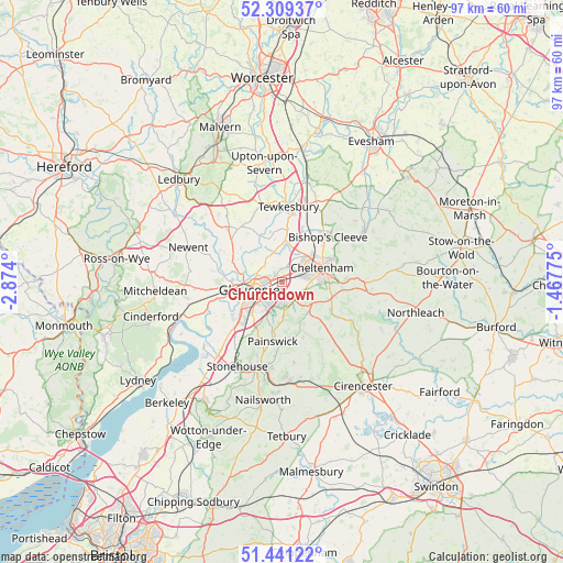
Churchdown GPS coordinates[2]
51° 52' 38.604" North, 2° 10' 15.132" West
| Map corner | latitude | longitude |
|---|---|---|
| Upper-left | 52.30937°, | -2.874° |
| Center: | 51.87739°, | -2.17087° |
| Lower-right: | 51.44122°, | -1.46775° |
| Map W x H: | 96.5×96.5 km | = 60×60mi |
| max Lat: | 60.39635° ⇑65.6% North |
| Churchdown: | 51.87739° |
| min Lat: | ⇓34.4% South 34.60088° |
| min Long | Churchdown | max Long |
| -7.64133° | -2.17087° | 32.95536° |
| W 41.6%⇐ | ⇒58.4% E |
Elevation
Elevation of Churchdown is 51 m = 167 ft, and this is 21.9 m = 72 ft below average elevation for this country.
| Max E: |
515 m = 1690 ft | 56.8% |
| Avg. | 72.9 m = 239 ft | |
| Churchdown | 51 m = 167 ft | |
Min E: |
-30 m = -98 ft | 43.2% |
See also: United Kingdom elevation on elevation.city.
Geographical zone
Churchdown is located in North temperate zone (between Tropic of Cancer and the Arctic Circle). Distance of this North polar circle is 1632.9 km =1014.6 mi to North.| Distance of | km | miles | from Churchdown |
|---|---|---|---|
| North Pole | 4238.8 | 2633.9 | to North |
| Arctic Circle | 1632.9 | 1014.6 | to North |
| Tropic Cancer | 3162.3 | 1965 | to South |
| Equator | 5768.2 | 3584.2 | to South |


Nearby cities:
15 places around Churchdown: (largest is in red/bold)
• Apperley
8.6 km =5.3 mi,  345°
345°
• Ashleworth
9.2 km =5.7 mi,  308°
308°
• Barnwood
2.5 km =1.6 mi,  233°
233°
• Bishops Cleeve
10.8 km =6.7 mi,  43°
43°
• Charlton Kings
8.8 km =5.5 mi,  85°
85°
• Cheltenham
6.7 km =4.2 mi,  68°
68°
• Gloucester
5.1 km =3.2 mi,  255°
255°
• Gotherington
12.6 km =7.8 mi, 39°
• Hartpury
9.9 km =6.2 mi,  301°
301°
• Painswick
10.3 km =6.4 mi,  189°
189°
• Shurdington
3.8 km =2.4 mi,  115°
115°
• Swindon
7.2 km =4.5 mi, 44°
• Tewkesbury
12.8 km =8 mi,  3°
3°
• Twigworth
4.4 km =2.7 mi, 305°
• Uckington
6 km =3.7 mi,  31°
31°
Sources, notices
• [Note1] Compared only with cities in United Kingdom existing in our database
• [Src1] Map data: © OpenStreetMap contributors (CC-BY-SA)
• [Src2] Other city data from geonames.org with taken over terms of usage.
• [Src3] Geographical zone / Annual Mean Temperature by Robert A. Rohde @ Wikipedia
