Cheltenham geodata
Cheltenham (England) is a populated place; located in United Kingdom in Europe/London (GMT+1) time zone. With population of 116,447 people, there are 81 cities with bigger population in this country. Compared to other cities in United Kingdom, 64.9% of cities are located further ↑North; 56.2% of cities are located further →East and 50.4% of cities have higher elevation than Cheltenham. Note1


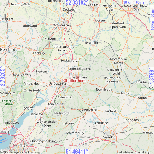
Cheltenham GPS coordinates[2]
51° 54' 0.216" North, 2° 4' 46.992" West
| Map corner | latitude | longitude |
|---|---|---|
| Upper-left | 52.33182°, | -2.78285° |
| Center: | 51.90006°, | -2.07972° |
| Lower-right: | 51.46411°, | -1.3766° |
| Map W x H: | 96.5×96.5 km | = 60×60mi |
| max Lat: | 60.39635° ⇑64.9% North |
| Cheltenham: | 51.90006° |
| min Lat: | ⇓35.1% South 34.60088° |
| min Long | Cheltenham | max Long |
| -7.64133° | -2.07972° | 32.95536° |
| W 43.8%⇐ | ⇒56.2% E |
Elevation
Elevation of Cheltenham is 60 m = 197 ft, and this is 12.9 m = 42 ft below average elevation for this country.
| Max E: |
515 m = 1690 ft | 50.4% |
| Avg. | 72.9 m = 239 ft | |
| Cheltenham | 60 m = 197 ft | |
Min E: |
-30 m = -98 ft | 49.6% |
See also: Cheltenham elevation on elevation.city.
Geographical zone
Cheltenham is located in North temperate zone (between Tropic of Cancer and the Arctic Circle). Distance of this North polar circle is 1630.4 km =1013.1 mi to North.| Distance of | km | miles | from Cheltenham |
|---|---|---|---|
| North Pole | 4236.3 | 2632.3 | to North |
| Arctic Circle | 1630.4 | 1013.1 | to North |
| Tropic Cancer | 3164.8 | 1966.5 | to South |
| Equator | 5770.7 | 3585.7 | to South |


Nearby cities:
15 places around Cheltenham: (largest is in red/bold)
• Andoversford
8.1 km =5 mi,  110°
110°
• Apperley
10.2 km =6.3 mi,  305°
305°
• Barnwood
9.2 km =5.7 mi,  244°
244°
• Bishops Cleeve
5.4 km =3.4 mi,  12°
12°
• Charlton Kings
3.1 km =1.9 mi,  125°
125°
• Churchdown
6.7 km =4.2 mi,  248°
248°
• Gloucester
11.8 km =7.3 mi, 251°
• Gotherington
7.4 km =4.6 mi, 13°
• Shipton
10 km =6.2 mi, 111°
• Shurdington
5 km =3.1 mi,  213°
213°
• Swindon
2.9 km =1.8 mi,  333°
333°
• Tewkesbury
11.7 km =7.3 mi, 331°
• Twigworth
9.8 km =6.1 mi,  270°
270°
• Uckington
4 km =2.5 mi, 309°
• Winchcombe
9.9 km =6.2 mi,  53°
53°
Sources, notices
• [Note1] Compared only with cities in United Kingdom existing in our database
• [Src1] Map data: © OpenStreetMap contributors (CC-BY-SA)
• [Src2] Other city data from geonames.org with taken over terms of usage.
• [Src3] Geographical zone / Annual Mean Temperature by Robert A. Rohde @ Wikipedia
