Llanrhaeadr-ym-Mochnant geodata
Llanrhaeadr-ym-Mochnant (Wales) is a seat of a third-order administrative division; located in United Kingdom in Europe/London (GMT+1) time zone. With population of 408 people, there are 4918 cities with bigger population in this country. Compared to other cities in United Kingdom, 57.9% of cities are located further ↓South; 79.6% of cities are located further →East and 90.9% of cities have lower elevation than Llanrhaeadr-ym-Mochnant. Note1
Current local time in Llanrhaeadr-ym-Mochnant:
04:33 AM, FridayDifference from your time zone: hours


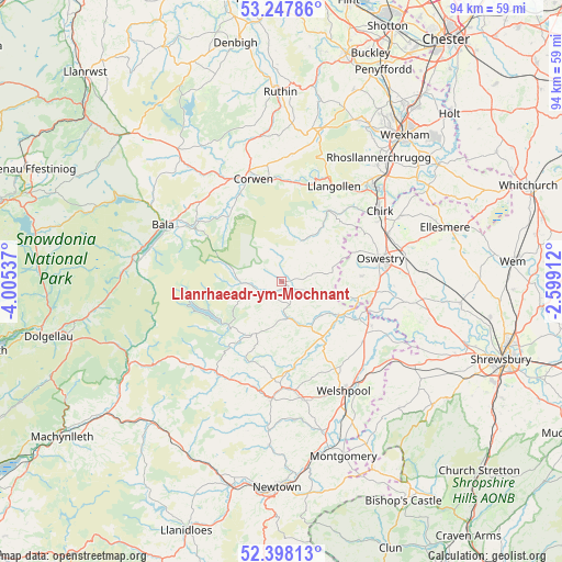
Llanrhaeadr-ym-Mochnant GPS coordinates[2]
52° 49' 30.252" North, 3° 18' 8.1" West
| Map corner | latitude | longitude |
|---|---|---|
| Upper-left | 53.24786°, | -4.00537° |
| Center: | 52.82507°, | -3.30225° |
| Lower-right: | 52.39813°, | -2.59912° |
| Map W x H: | 94.5×94.5 km | = 58.7×58.7mi |
| max Lat: | 60.39635° ⇑42.1% North |
| Llanrhaeadr-ym-Mochnant: | 52.82507° |
| min Lat: | ⇓57.9% South 34.60088° |
| min Long | Llanrhaeadr-ym- | max Long |
| -7.64133° | -3.30225° | 32.95536° |
| W 20.4%⇐ | ⇒79.6% E |
Elevation
Elevation of Llanrhaeadr-ym-Mochnant is 155 m = 509 ft, and this is 82.1 m = 269 ft above average elevation for this country.
| Max E: |
515 m = 1690 ft | 9.1% |
| Llanrhaeadr-ym-Mochnant | 155 m 509 ft | |
| Avg. | 72.9 m = 239 ft | |
Min E: |
-30 m = -98 ft | 90.9% |
See also: United Kingdom elevation on elevation.city.
Geographical zone
Llanrhaeadr-ym-Mochnant is located in North temperate zone (between Tropic of Cancer and the Arctic Circle). Distance of this North polar circle is 1527.6 km =949.2 mi to North.| Distance of | km | miles | from Llanrhaeadr-ym-Mochnant |
|---|---|---|---|
| North Pole | 4133.5 | 2568.4 | to North |
| Arctic Circle | 1527.6 | 949.2 | to North |
| Tropic Cancer | 3267.7 | 2030.5 | to South |
| Equator | 5873.6 | 3649.7 | to South |


Nearby cities:
15 places around Llanrhaeadr-ym-Mochnant: (largest is in red/bold)
• Chirk
20.5 km =12.7 mi,  53°
53°
• Cynwyd
16.5 km =10.3 mi,  334°
334°
• Four Crosses
16.6 km =10.3 mi,  116°
116°
• Gobowen
19.5 km =12.1 mi,  66°
66°
• Guilsfield
17.3 km =10.7 mi,  145°
145°
• Llandrillo
14.2 km =8.8 mi,  320°
320°
• Llanfair Caereinion
19.8 km =12.3 mi,  184°
184°
• Llanfechain
8.7 km =5.4 mi,  129°
129°
• Llanfyllin
6.9 km =4.3 mi,  162°
162°
• Llangollen
18.2 km =11.3 mi,  28°
28°
• Llangynog
6.6 km =4.1 mi,  277°
277°
• Llanymynech
15.2 km =9.4 mi,  108°
108°
• Oswestry
17.1 km =10.6 mi,  76°
76°
• Pant
15.4 km =9.6 mi,  104°
104°
• Trefonen
13.6 km =8.5 mi,  86°
86°
Sources, notices
• [Note1] Compared only with cities in United Kingdom existing in our database
• [Src1] Map data: © OpenStreetMap contributors (CC-BY-SA)
• [Src2] Other city data from geonames.org with taken over terms of usage.
• [Src3] Geographical zone / Annual Mean Temperature by Robert A. Rohde @ Wikipedia
