Stanley geodata
Stanley (England) is a populated place; located in United Kingdom in Europe/London (GMT+1) time zone. With population of 21,938 people, there are 542 cities with bigger population in this country. Compared to other cities in United Kingdom, 85.5% of cities are located further ↓South; 51% of cities are located further ←West and 98% of cities have lower elevation than Stanley. Note1


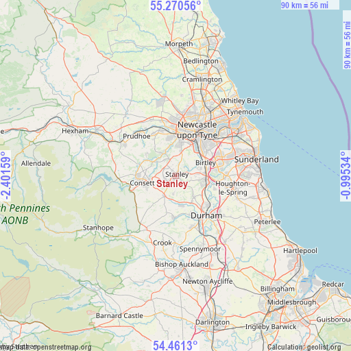
Stanley GPS coordinates[2]
54° 52' 4.656" North, 1° 41' 54.456" West
| Map corner | latitude | longitude |
|---|---|---|
| Upper-left | 55.27056°, | -2.40159° |
| Center: | 54.86796°, | -1.69846° |
| Lower-right: | 54.4613°, | -0.99534° |
| Map W x H: | 90×90 km | = 55.9×55.9mi |
| max Lat: | 60.39635° ⇑14.5% North |
| Stanley: | 54.86796° |
| min Lat: | ⇓85.5% South 34.60088° |
| min Long | Stanley | max Long |
| -7.64133° | -1.69846° | 32.95536° |
| W 51%⇐ | ⇒49% E |
Elevation
Elevation of Stanley is 225 m = 738 ft, and this is 152.1 m = 499 ft above average elevation for this country.
| Max E: |
515 m = 1690 ft | 2% |
| Stanley | 225 m 738 ft | |
| Avg. | 72.9 m = 239 ft | |
Min E: |
-30 m = -98 ft | 98% |
See also: United Kingdom elevation on elevation.city.
Geographical zone
Stanley is located in North temperate zone (between Tropic of Cancer and the Arctic Circle). Distance of this North polar circle is 1300.4 km =808 mi to North.| Distance of | km | miles | from Stanley |
|---|---|---|---|
| North Pole | 3906.3 | 2427.3 | to North |
| Arctic Circle | 1300.4 | 808 | to North |
| Tropic Cancer | 3494.8 | 2171.6 | to South |
| Equator | 6100.7 | 3790.8 | to South |


Nearby cities:
15 places around Stanley: (largest is in red/bold)
• Annfield Plain
2.8 km =1.7 mi,  245°
245°
• Burnopfield
4.6 km =2.9 mi,  338°
338°
• Chester-le-Street
8 km =5 mi,  97°
97°
• Chopwell
9.6 km =6 mi,  305°
305°
• Consett
8.7 km =5.4 mi,  259°
259°
• Ebchester
9.6 km =6 mi,  286°
286°
• Lamesley
7.8 km =4.8 mi,  47°
47°
• Lanchester
5.9 km =3.7 mi,  208°
208°
• Langley Park
7.8 km =4.8 mi,  166°
166°
• Pelton
5.7 km =3.5 mi,  84°
84°
• Rowlands Gill
6.4 km =4 mi,  332°
332°
• Sacriston
7.3 km =4.5 mi,  139°
139°
• Tanfield
2.9 km =1.8 mi, 341°
• Whickham
8.7 km =5.4 mi,  9°
9°
• Witton Gilbert
8 km =5 mi,  150°
150°
Sources, notices
• [Note1] Compared only with cities in United Kingdom existing in our database
• [Src1] Map data: © OpenStreetMap contributors (CC-BY-SA)
• [Src2] Other city data from geonames.org with taken over terms of usage.
• [Src3] Geographical zone / Annual Mean Temperature by Robert A. Rohde @ Wikipedia
