Chester-le-Street geodata
Chester-le-Street (England) is a populated place; located in United Kingdom in Europe/London (GMT+1) time zone. With population of 36,917 people, there are 330 cities with bigger population in this country. Compared to other cities in United Kingdom, 85.4% of cities are located further ↓South; 53.9% of cities are located further ←West and 88.2% of cities have higher elevation than Chester-le-Street. Note1


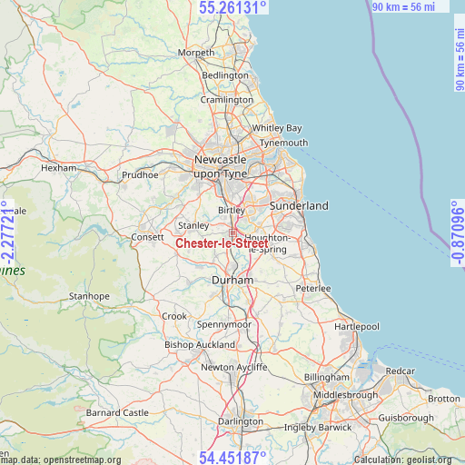
Chester-le-Street GPS coordinates[2]
54° 51' 31.032" North, 1° 34' 26.688" West
| Map corner | latitude | longitude |
|---|---|---|
| Upper-left | 55.26131°, | -2.27721° |
| Center: | 54.85862°, | -1.57408° |
| Lower-right: | 54.45187°, | -0.87096° |
| Map W x H: | 90×90 km | = 55.9×55.9mi |
| max Lat: | 60.39635° ⇑14.6% North |
| Chester-le-Street: | 54.85862° |
| min Lat: | ⇓85.4% South 34.60088° |
| min Long | Chester-le-Stre | max Long |
| -7.64133° | -1.57408° | 32.95536° |
| W 53.9%⇐ | ⇒46.1% E |
Elevation
Elevation of Chester-le-Street is 13 m = 43 ft, and this is 59.9 m = 197 ft below average elevation for this country.
| Max E: |
515 m = 1690 ft | 88.2% |
| Avg. | 72.9 m = 239 ft | |
| Chester-le-Street | 13 m = 43 ft | |
Min E: |
-30 m = -98 ft | 11.8% |
See also: United Kingdom elevation on elevation.city.
Geographical zone
Chester-le-Street is located in North temperate zone (between Tropic of Cancer and the Arctic Circle). Distance of this North polar circle is 1301.5 km =808.7 mi to North.| Distance of | km | miles | from Chester-le-Street |
|---|---|---|---|
| North Pole | 3907.4 | 2427.9 | to North |
| Arctic Circle | 1301.5 | 808.7 | to North |
| Tropic Cancer | 3493.8 | 2170.9 | to South |
| Equator | 6099.7 | 3790.2 | to South |


Nearby cities:
15 places around Chester-le-Street: (largest is in red/bold)
• Durham
9.1 km =5.7 mi,  180°
180°
• East Rainton
7.1 km =4.4 mi,  121°
121°
• Hetton-Le-Hole
9.2 km =5.7 mi, 120°
• Houghton-Le-Spring
7.3 km =4.5 mi,  106°
106°
• Lamesley
6.7 km =4.2 mi,  340°
340°
• Langley Park
9 km =5.6 mi,  223°
223°
• Pelton
2.8 km =1.7 mi,  305°
305°
• Pittington
8.7 km =5.4 mi,  138°
138°
• Sacriston
5.6 km =3.5 mi, 215°
• Stanley
8 km =5 mi,  277°
277°
• Tanfield
9.7 km =6 mi,  293°
293°
• Ushaw Moor
10.1 km =6.3 mi,  207°
207°
• Washington
5.9 km =3.7 mi,  38°
38°
• West Rainton
6.7 km =4.2 mi,  134°
134°
• Witton Gilbert
7.1 km =4.4 mi, 214°
Sources, notices
• [Note1] Compared only with cities in United Kingdom existing in our database
• [Src1] Map data: © OpenStreetMap contributors (CC-BY-SA)
• [Src2] Other city data from geonames.org with taken over terms of usage.
• [Src3] Geographical zone / Annual Mean Temperature by Robert A. Rohde @ Wikipedia
