Lamesley geodata
Lamesley (England) is a seat of a third-order administrative division; located in United Kingdom in Europe/London (GMT+0) time zone. With population of 3,928 people, there are 1861 cities with bigger population in this country. Compared to other cities in United Kingdom, 85.9% of cities are located further ↓South; 53% of cities are located further ←West and 89.9% of cities have higher elevation than Lamesley. Note1


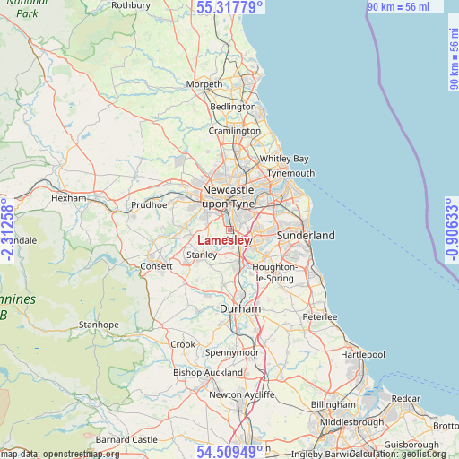
Lamesley GPS coordinates[2]
54° 54' 56.412" North, 1° 36' 34.02" West
| Map corner | latitude | longitude |
|---|---|---|
| Upper-left | 55.31779°, | -2.31258° |
| Center: | 54.91567°, | -1.60945° |
| Lower-right: | 54.50949°, | -0.90633° |
| Map W x H: | 89.9×89.9 km | = 55.9×55.9mi |
| max Lat: | 60.39635° ⇑14.1% North |
| Lamesley: | 54.91567° |
| min Lat: | ⇓85.9% South 34.60088° |
| min Long | Lamesley | max Long |
| -7.64133° | -1.60945° | 32.95536° |
| W 53%⇐ | ⇒47% E |
Elevation
Elevation of Lamesley is 12 m = 39 ft, and this is 60.9 m = 200 ft below average elevation for this country.
| Max E: |
515 m = 1690 ft | 89.9% |
| Avg. | 72.9 m = 239 ft | |
| Lamesley | 12 m = 39 ft | |
Min E: |
-30 m = -98 ft | 10.1% |
See also: United Kingdom elevation on elevation.city.
Geographical zone
Lamesley is located in North temperate zone (between Tropic of Cancer and the Arctic Circle). Distance of this North polar circle is 1295.1 km =804.7 mi to North.| Distance of | km | miles | from Lamesley |
|---|---|---|---|
| North Pole | 3901 | 2424 | to North |
| Arctic Circle | 1295.1 | 804.7 | to North |
| Tropic Cancer | 3500.1 | 2174.9 | to South |
| Equator | 6106.1 | 3794.2 | to South |


Nearby cities:
15 places around Lamesley: (largest is in red/bold)
• Benwell
7.4 km =4.6 mi,  329°
329°
• Blaydon-on-Tyne
8.6 km =5.3 mi,  309°
309°
• Burnopfield
7.5 km =4.7 mi,  261°
261°
• Chester-le-Street
6.7 km =4.2 mi,  160°
160°
• Felling
4.8 km =3 mi,  30°
30°
• Gateshead
5.2 km =3.2 mi,  5°
5°
• Gosforth
9.4 km =5.8 mi,  357°
357°
• Hebburn
8.8 km =5.5 mi,  43°
43°
• Newcastle upon Tyne
6.4 km =4 mi, 357°
• Pelton
4.7 km =2.9 mi,  180°
180°
• Rowlands Gill
8.7 km =5.4 mi,  272°
272°
• Stanley
7.8 km =4.8 mi,  227°
227°
• Tanfield
7.1 km =4.4 mi,  249°
249°
• Washington
6.2 km =3.9 mi,  106°
106°
• Whickham
5.4 km =3.4 mi, 307°
Sources, notices
• [Note1] Compared only with cities in United Kingdom existing in our database
• [Src1] Map data: © OpenStreetMap contributors (CC-BY-SA)
• [Src2] Other city data from geonames.org with taken over terms of usage.
• [Src3] Geographical zone / Annual Mean Temperature by Robert A. Rohde @ Wikipedia
