Washwood Heath geodata
Washwood Heath (England) is a section of populated place; located in United Kingdom in Europe/London (GMT+1) time zone. With population of 32,921 people, there are 373 cities with bigger population in this country. Compared to other cities in United Kingdom, 50.3% of cities are located further ↓South; 51.5% of cities are located further →East and 72.2% of cities have lower elevation than Washwood Heath. Note1


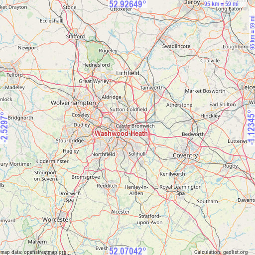
Washwood Heath GPS coordinates[2]
52° 30' 1.944" North, 1° 49' 35.652" West
| Map corner | latitude | longitude |
|---|---|---|
| Upper-left | 52.92649°, | -2.5297° |
| Center: | 52.50054°, | -1.82657° |
| Lower-right: | 52.07042°, | -1.12345° |
| Map W x H: | 95.2×95.2 km | = 59.2×59.2mi |
| max Lat: | 60.39635° ⇑49.7% North |
| Washwood Heath: | 52.50054° |
| min Lat: | ⇓50.3% South 34.60088° |
| min Long | Washwood Heath | max Long |
| -7.64133° | -1.82657° | 32.95536° |
| W 48.5%⇐ | ⇒51.5% E |
Elevation
Elevation of Washwood Heath is 100 m = 328 ft, and this is 27.1 m = 89 ft above average elevation for this country.
| Max E: |
515 m = 1690 ft | 27.8% |
| Washwood Heath | 100 m 328 ft | |
| Avg. | 72.9 m = 239 ft | |
Min E: |
-30 m = -98 ft | 72.2% |
See also: United Kingdom elevation on elevation.city.
Geographical zone
Washwood Heath is located in North temperate zone (between Tropic of Cancer and the Arctic Circle). Distance of this North polar circle is 1563.7 km =971.6 mi to North.| Distance of | km | miles | from Washwood Heath |
|---|---|---|---|
| North Pole | 4169.5 | 2590.8 | to North |
| Arctic Circle | 1563.7 | 971.6 | to North |
| Tropic Cancer | 3231.6 | 2008 | to South |
| Equator | 5837.5 | 3627.3 | to South |


Nearby cities:
15 places around Washwood Heath: (largest is in red/bold)
• Acocks Green
5.7 km =3.5 mi,  173°
173°
• Aston
3.8 km =2.4 mi,  269°
269°
• Bickenhill
9.6 km =6 mi,  134°
134°
• Birmingham
5.4 km =3.4 mi,  246°
246°
• Castle Vale
2.9 km =1.8 mi,  44°
44°
• Chelmsley Wood
6.5 km =4 mi,  112°
112°
• Curdworth
7.1 km =4.4 mi,  58°
58°
• Hockley
6.1 km =3.8 mi, 269°
• Shirley
10 km =6.2 mi,  177°
177°
• Smethwick
9.6 km =6 mi,  264°
264°
• Solihull
10.1 km =6.3 mi,  162°
162°
• Streetly
10 km =6.2 mi,  337°
337°
• Sutton Coldfield
7.4 km =4.6 mi,  5°
5°
• Water Orton
6.1 km =3.8 mi,  73°
73°
• West Bromwich
11.5 km =7.1 mi,  280°
280°
Sources, notices
• [Note1] Compared only with cities in United Kingdom existing in our database
• [Src1] Map data: © OpenStreetMap contributors (CC-BY-SA)
• [Src2] Other city data from geonames.org with taken over terms of usage.
• [Src3] Geographical zone / Annual Mean Temperature by Robert A. Rohde @ Wikipedia
