Birmingham geodata
Birmingham (England) is a seat of a second-order administrative division; located in United Kingdom in Europe/London (GMT+0) time zone. With population of 984,333 people, there is 1 city with bigger population in this country. Compared to other cities in United Kingdom, 50.2% of cities are located further ↑North; 52.9% of cities are located further →East and 89.6% of cities have lower elevation than Birmingham. Note1


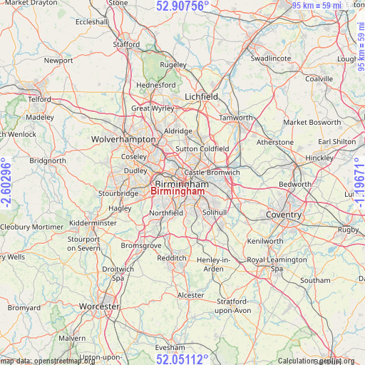
Birmingham GPS coordinates[2]
52° 28' 53.112" North, 1° 53' 59.388" West
| Map corner | latitude | longitude |
|---|---|---|
| Upper-left | 52.90756°, | -2.60296° |
| Center: | 52.48142°, | -1.89983° |
| Lower-right: | 52.05112°, | -1.19671° |
| Map W x H: | 95.2×95.2 km | = 59.2×59.2mi |
| max Lat: | 60.39635° ⇑50.2% North |
| Birmingham: | 52.48142° |
| min Lat: | ⇓49.8% South 34.60088° |
| min Long | Birmingham | max Long |
| -7.64133° | -1.89983° | 32.95536° |
| W 47.1%⇐ | ⇒52.9% E |
Elevation
Elevation of Birmingham is 149 m = 489 ft, and this is 76.1 m = 250 ft above average elevation for this country.
| Max E: |
515 m = 1690 ft | 10.4% |
| Birmingham | 149 m 489 ft | |
| Avg. | 72.9 m = 239 ft | |
Min E: |
-30 m = -98 ft | 89.6% |
See also: Birmingham elevation on elevation.city.
Geographical zone
Birmingham is located in North temperate zone (between Tropic of Cancer and the Arctic Circle). Distance of this North polar circle is 1565.8 km =972.9 mi to North.| Distance of | km | miles | from Birmingham |
|---|---|---|---|
| North Pole | 4171.7 | 2592.2 | to North |
| Arctic Circle | 1565.8 | 972.9 | to North |
| Tropic Cancer | 3229.5 | 2006.7 | to South |
| Equator | 5835.4 | 3625.9 | to South |


Nearby cities:
15 places around Birmingham: (largest is in red/bold)
• Acocks Green
6.6 km =4.1 mi,  121°
121°
• Aston
2.3 km =1.4 mi,  28°
28°
• Bartley Green
8.3 km =5.2 mi,  232°
232°
• Castle Vale
8.1 km =5 mi,  59°
59°
• Chelmsley Wood
11 km =6.8 mi,  91°
91°
• Halesowen
10.8 km =6.7 mi,  250°
250°
• Hockley
2.4 km =1.5 mi,  331°
331°
• Oldbury
8.2 km =5.1 mi,  284°
284°
• Rowley Regis
9.7 km =6 mi,  270°
270°
• Shirley
9.6 km =6 mi,  145°
145°
• Smethwick
4.7 km =2.9 mi,  285°
285°
• Solihull
11 km =6.8 mi,  132°
132°
• Sutton Coldfield
11 km =6.8 mi, 30°
• Washwood Heath
5.4 km =3.4 mi,  66°
66°
• West Bromwich
7.6 km =4.7 mi,  302°
302°
Sources, notices
• [Note1] Compared only with cities in United Kingdom existing in our database
• [Src1] Map data: © OpenStreetMap contributors (CC-BY-SA)
• [Src2] Other city data from geonames.org with taken over terms of usage.
• [Src3] Geographical zone / Annual Mean Temperature by Robert A. Rohde @ Wikipedia
