Mtskheta geodata
Mtskheta (Mtskheta-Mtianeti) is a seat of a first-order administrative division; located in Georgia in Asia/Tbilisi (GMT+4) time zone. With population of 7,423 people, there are 45 cities with bigger population in this country. Compared to other cities in Georgia, 63.2% of cities are located further ↑North; 83.8% of cities are located further ←West and 53.8% of cities have higher elevation than Mtskheta. Note1


Mtskheta GPS coordinates[2]
41° 50' 42.504" North, 44° 43' 7.5" East
| Map corner | latitude | longitude |
|---|---|---|
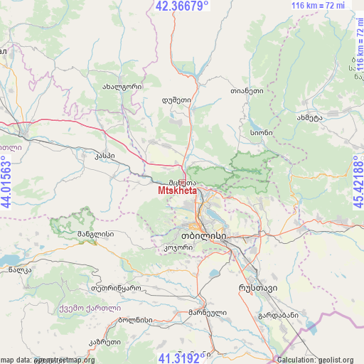
| Upper-left | 42.36679°, | 44.01563° |
| Center: | 41.84514°, | 44.71875° |
| Lower-right: | 41.3192°, | 45.42188° |
| Map W x H: | 116.5×116.5 km | = 72.4×72.4mi |
| max Lat: | 43.38111° ⇑63.2% North |
| Mtskheta: | 41.84514° |
| min Lat: | ⇓36.8% South 41.21725° |
| min Long | Mtskheta | max Long |
| 40.07944° | 44.71875° | 46.27667° |
| W 83.8%⇐ | ⇒16.2% E |
Elevation
Elevation of Mtskheta is 476 m = 1562 ft, and this is 102.8 m = 337 ft below average elevation for this country.
| Max E: |
2223 m = 7293 ft | 53.8% |
| Avg. | 578.8 m = 1899 ft | |
| Mtskheta | 476 m = 1562 ft | |
Min E: |
1 m = 3 ft | 46.2% |
See also: Georgia elevation on elevation.city.
Geographical zone
Mtskheta is located in North temperate zone (between Tropic of Cancer and the Arctic Circle). Distance of this Northern Tropic circle is 2046.8 km =1271.8 mi to South.| Distance of | km | miles | from Mtskheta |
|---|---|---|---|
| North Pole | 5354.3 | 3327 | to North |
| Arctic Circle | 2748.4 | 1707.8 | to North |
| Tropic Cancer | 2046.8 | 1271.8 | to South |
| Equator | 4652.7 | 2891.1 | to South |


Nearby cities:
15 places around Mtskheta: (largest is in red/bold)
• Akhalgori
36.8 km =22.9 mi,  328°
328°
• Didi Lilo
23.7 km =14.7 mi,  120°
120°
• Dzegvi
9.8 km =6.1 mi,  270°
270°
• Kaspi
25.8 km =16 mi,  290°
290°
• Kojori
20.8 km =12.9 mi,  184°
184°
• Manglisi
32.2 km =20 mi,  239°
239°
• Marneuli
41.7 km =25.9 mi,  169°
169°
• Rust’avi
40 km =24.9 mi,  145°
145°
• Samt’avisi
31.3 km =19.4 mi,  305°
305°
• Tbilisi
19.3 km =12 mi, 150°
• Tsqnet’i
16.8 km =10.4 mi,  185°
185°
• T’et’ri Tsqaro
39.7 km =24.7 mi,  212°
212°
• T’ianet’i
35.6 km =22.1 mi,  34°
34°
• Zahesi
3.7 km =2.3 mi,  128°
128°
• Zhinvali
32.2 km =20 mi,  7°
7°
Sources, notices
• [Note1] Compared only with cities in Georgia existing in our database
• [Src1] Map data: © OpenStreetMap contributors (CC-BY-SA)
• [Src2] Other city data from geonames.org with taken over terms of usage.
• [Src3] Geographical zone / Annual Mean Temperature by Robert A. Rohde @ Wikipedia
