Dzegvi geodata
Dzegvi (Mtskheta-Mtianeti) is a populated place; located in Georgia in Asia/Tbilisi (GMT+4) time zone. With population of 2,911 people, there are 73 cities with bigger population in this country. Compared to other cities in Georgia, 62.4% of cities are located further ↑North; 79.5% of cities are located further ←West and 51.3% of cities have lower elevation than Dzegvi. Note1


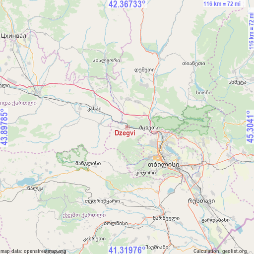
Dzegvi GPS coordinates[2]
41° 50' 44.484" North, 44° 36' 3.492" East
| Map corner | latitude | longitude |
|---|---|---|
| Upper-left | 42.36733°, | 43.89785° |
| Center: | 41.84569°, | 44.60097° |
| Lower-right: | 41.31976°, | 45.3041° |
| Map W x H: | 116.5×116.5 km | = 72.4×72.4mi |
| max Lat: | 43.38111° ⇑62.4% North |
| Dzegvi: | 41.84569° |
| min Lat: | ⇓37.6% South 41.21725° |
| min Long | Dzegvi | max Long |
| 40.07944° | 44.60097° | 46.27667° |
| W 79.5%⇐ | ⇒20.5% E |
Elevation
Elevation of Dzegvi is 503 m = 1650 ft, and this is 75.8 m = 249 ft below average elevation for this country.
| Max E: |
2223 m = 7293 ft | 48.7% |
| Avg. | 578.8 m = 1899 ft | |
| Dzegvi | 503 m = 1650 ft | |
Min E: |
1 m = 3 ft | 51.3% |
See also: Georgia elevation on elevation.city.
Geographical zone
Dzegvi is located in North temperate zone (between Tropic of Cancer and the Arctic Circle). Distance of this Northern Tropic circle is 2046.9 km =1271.9 mi to South.| Distance of | km | miles | from Dzegvi |
|---|---|---|---|
| North Pole | 5354.3 | 3327 | to North |
| Arctic Circle | 2748.4 | 1707.8 | to North |
| Tropic Cancer | 2046.9 | 1271.9 | to South |
| Equator | 4652.8 | 2891.1 | to South |


Nearby cities:
15 places around Dzegvi: (largest is in red/bold)
• Akhalgori
32.6 km =20.3 mi,  342°
342°
• Didi Lilo
32.5 km =20.2 mi,  112°
112°
• Dmanisi
41.4 km =25.7 mi,  210°
210°
• Kaspi
17 km =10.6 mi,  301°
301°
• Kojori
22.3 km =13.9 mi,  158°
158°
• Manglisi
24.4 km =15.2 mi,  227°
227°
• Mtskheta
9.8 km =6.1 mi,  90°
90°
• Samt’avisi
24 km =14.9 mi,  318°
318°
• Tbilisi
25.6 km =15.9 mi,  131°
131°
• Tsqnet’i
18.6 km =11.6 mi,  154°
154°
• T’et’ri Tsqaro
35.4 km =22 mi,  199°
199°
• T’ianet’i
41.9 km =26 mi,  45°
45°
• Uplistsikhe
38 km =23.6 mi,  290°
290°
• Zahesi
12.9 km =8 mi,  100°
100°
• Zhinvali
34.8 km =21.6 mi,  24°
24°
Sources, notices
• [Note1] Compared only with cities in Georgia existing in our database
• [Src1] Map data: © OpenStreetMap contributors (CC-BY-SA)
• [Src2] Other city data from geonames.org with taken over terms of usage.
• [Src3] Geographical zone / Annual Mean Temperature by Robert A. Rohde @ Wikipedia
