Akhalgori geodata
Akhalgori (Mtskheta-Mtianeti) is a populated place; located in Georgia in Asia/Tbilisi (GMT+4) time zone. With population of 1,420 people, there are 91 cities with bigger population in this country. Compared to other cities in Georgia, 58.1% of cities are located further ↓South; 76.9% of cities are located further ←West and 73.5% of cities have lower elevation than Akhalgori. Note1


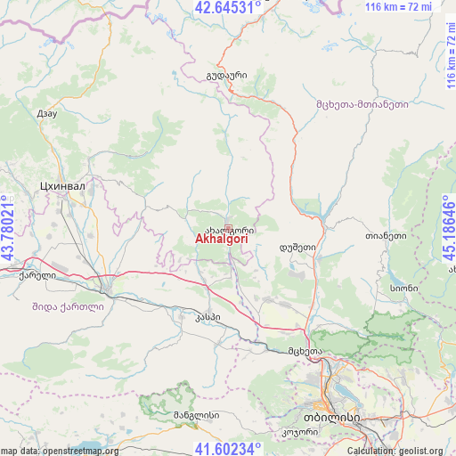
Akhalgori GPS coordinates[2]
42° 7' 33.492" North, 44° 28' 59.988" East
| Map corner | latitude | longitude |
|---|---|---|
| Upper-left | 42.64531°, | 43.78021° |
| Center: | 42.12597°, | 44.48333° |
| Lower-right: | 41.60234°, | 45.18646° |
| Map W x H: | 116×116 km | = 72.1×72.1mi |
| max Lat: | 43.38111° ⇑41.9% North |
| Akhalgori: | 42.12597° |
| min Lat: | ⇓58.1% South 41.21725° |
| min Long | Akhalgori | max Long |
| 40.07944° | 44.48333° | 46.27667° |
| W 76.9%⇐ | ⇒23.1% E |
Elevation
Elevation of Akhalgori is 822 m = 2697 ft, and this is 243.2 m = 798 ft above average elevation for this country.
| Max E: |
2223 m = 7293 ft | 26.5% |
| Akhalgori | 822 m 2697 ft | |
| Avg. | 578.8 m = 1899 ft | |
Min E: |
1 m = 3 ft | 73.5% |
See also: Georgia elevation on elevation.city.
Geographical zone
Akhalgori is located in North temperate zone (between Tropic of Cancer and the Arctic Circle). Distance of this Northern Tropic circle is 2078 km =1291.2 mi to South.| Distance of | km | miles | from Akhalgori |
|---|---|---|---|
| North Pole | 5323.1 | 3307.6 | to North |
| Arctic Circle | 2717.2 | 1688.4 | to North |
| Tropic Cancer | 2078 | 1291.2 | to South |
| Equator | 4684 | 2910.5 | to South |


Nearby cities:
15 places around Akhalgori: (largest is in red/bold)
• Dzegvi
32.6 km =20.3 mi,  162°
162°
• Gori
34.2 km =21.3 mi,  242°
242°
• Gudauri
39.1 km =24.3 mi,  359°
359°
• Kaspi
22.8 km =14.2 mi,  192°
192°
• Khet’agurovi
49.5 km =30.8 mi,  280°
280°
• Manglisi
48.4 km =30.1 mi, 189°
• Mtskheta
36.8 km =22.9 mi,  148°
148°
• P’asanauri
30.2 km =18.8 mi,  34°
34°
• Samt’avisi
14.5 km =9 mi,  204°
204°
• Tbeti
48.4 km =30.1 mi, 283°
• Ts’khinvali
43.9 km =27.3 mi, 284°
• T’ianet’i
39.7 km =24.7 mi,  92°
92°
• Uplistsikhe
31.3 km =19.4 mi, 235°
• Zahesi
40.3 km =25 mi, 146°
• Zhinvali
23.9 km =14.9 mi, 88°
Sources, notices
• [Note1] Compared only with cities in Georgia existing in our database
• [Src1] Map data: © OpenStreetMap contributors (CC-BY-SA)
• [Src2] Other city data from geonames.org with taken over terms of usage.
• [Src3] Geographical zone / Annual Mean Temperature by Robert A. Rohde @ Wikipedia
