Torteval geodata
Torteval is a seat of a first-order administrative division; located in Guernsey in Europe/Guernsey (GMT+1) time zone. In our database, there are 2 cities with bigger population. Compared to other cities in Guernsey, 87.5% of cities are located further ↑North; 100% of cities are located further →East and 50% of cities have lower elevation than Torteval. Note1


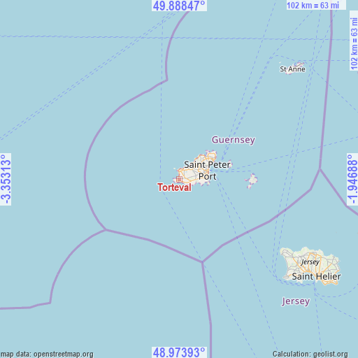
Torteval GPS coordinates[2]
49° 25' 59.988" North, 2° 39' 0" West
| Map corner | latitude | longitude |
|---|---|---|
| Upper-left | 49.88847°, | -3.35313° |
| Center: | 49.43333°, | -2.65° |
| Lower-right: | 48.97393°, | -1.94688° |
| Map W x H: | 101.7×101.7 km | = 63.2×63.2mi |
| max Lat: | 49.71549° ⇑87.5% North |
| Torteval: | 49.43333° |
| min Lat: | ⇓12.5% South 49.43331° |
| min Long | Torteval | max Long |
| -2.65° | -2.65° | -2.20757° |
| W 0%⇐ | ⇒100% E |
Elevation
Elevation of Torteval is 50 m = 164 ft, and this is 3.2 m = 10 ft above average elevation for this country.
| Max E: |
99 m = 325 ft | 50% |
| Torteval | 50 m 164 ft | |
| Avg. | 46.8 m = 154 ft | |
Min E: |
3 m = 10 ft | 50% |
See also: Guernsey elevation on elevation.city.
Geographical zone
Torteval is located in North temperate zone (between Tropic of Cancer and the Arctic Circle). Distance of this North polar circle is 1904.7 km =1183.5 mi to North.| Distance of | km | miles | from Torteval |
|---|---|---|---|
| North Pole | 4510.6 | 2802.8 | to North |
| Arctic Circle | 1904.7 | 1183.5 | to North |
| Tropic Cancer | 2890.6 | 1796.1 | to South |
| Equator | 5496.5 | 3415.4 | to South |


Nearby cities:
8 places around Torteval: (largest is in red/bold)
• Castel
5.2 km =3.2 mi,  43°
43°
• Saint Andrew
5.2 km =3.2 mi,  76°
76°
• Saint Peter Port
8.8 km =5.5 mi,  70°
70°
• Saint Sampson
10.7 km =6.6 mi,  58°
58°
• Saint Saviour
2.8 km =1.7 mi,  21°
21°
• Sark
21.2 km =13.2 mi,  90°
90°
• St Anne
44.7 km =27.8 mi,  45°
45°
• St Martin
6.9 km =4.3 mi, 86°
Sources, notices
• [Note1] Compared only with cities in Guernsey existing in our database
• [Src1] Map data: © OpenStreetMap contributors (CC-BY-SA)
• [Src2] Other city data from geonames.org with taken over terms of usage.
• [Src3] Geographical zone / Annual Mean Temperature by Robert A. Rohde @ Wikipedia
