St Anne geodata
St Anne (Alderney) is a seat of a first-order administrative division; located in Guernsey in Europe/Guernsey (GMT+1) time zone. In our database, there are 2 cities with bigger population. Compared to other cities in Guernsey, 100% of cities are located further ↓South; 100% of cities are located further ←West and 62.5% of cities have lower elevation than St Anne. Note1


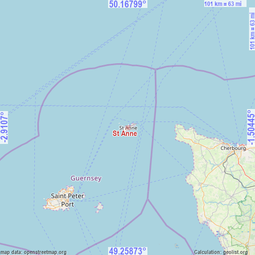
St Anne GPS coordinates[2]
49° 42' 55.764" North, 2° 12' 27.252" West
| Map corner | latitude | longitude |
|---|---|---|
| Upper-left | 50.16799°, | -2.9107° |
| Center: | 49.71549°, | -2.20757° |
| Lower-right: | 49.25873°, | -1.50445° |
| Map W x H: | 101.1×101.1 km | = 62.8×62.8mi |
| max Lat: | 49.71549° ⇑0% North |
| St Anne: | 49.71549° |
| min Lat: | ⇓100% South 49.43331° |
| min Long | St Anne | max Long |
| -2.65° | -2.20757° | -2.20757° |
| W 100%⇐ | ⇒0% E |
Elevation
Elevation of St Anne is 65 m = 213 ft, and this is 18.2 m = 60 ft above average elevation for this country.
| Max E: |
99 m = 325 ft | 37.5% |
| St Anne | 65 m 213 ft | |
| Avg. | 46.8 m = 154 ft | |
Min E: |
3 m = 10 ft | 62.5% |
See also: Guernsey elevation on elevation.city.
Geographical zone
St Anne is located in North temperate zone (between Tropic of Cancer and the Arctic Circle). Distance of this North polar circle is 1873.3 km =1164 mi to North.| Distance of | km | miles | from St Anne |
|---|---|---|---|
| North Pole | 4479.2 | 2783.2 | to North |
| Arctic Circle | 1873.3 | 1164 | to North |
| Tropic Cancer | 2921.9 | 1815.6 | to South |
| Equator | 5527.8 | 3434.8 | to South |


Nearby cities:
8 places around St Anne: (largest is in red/bold)
• Castel
39.5 km =24.5 mi,  225°
225°
• Saint Andrew
40.4 km =25.1 mi,  221°
221°
• Saint Peter Port
37 km =23 mi, 219°
• Saint Sampson
34.4 km =21.4 mi, 221°
• Saint Saviour
42.2 km =26.2 mi, 227°
• Sark
33.2 km =20.6 mi,  198°
198°
• St Martin
39.8 km =24.7 mi, 218°
• Torteval
44.7 km =27.8 mi, 225°
Sources, notices
• [Note1] Compared only with cities in Guernsey existing in our database
• [Src1] Map data: © OpenStreetMap contributors (CC-BY-SA)
• [Src2] Other city data from geonames.org with taken over terms of usage.
• [Src3] Geographical zone / Annual Mean Temperature by Robert A. Rohde @ Wikipedia
