Saint Peter Port geodata
Saint Peter Port (St Peter Port) is a capital of a political entity; located in Guernsey in Europe/Guernsey (GMT+1) time zone. With population of 16,488 people, there are 0 cities with bigger population in this country. Compared to other cities in Guernsey, 62.5% of cities are located further ↓South; 62.5% of cities are located further ←West and 75% of cities have higher elevation than Saint Peter Port. Note1


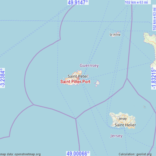
Saint Peter Port GPS coordinates[2]
49° 27' 35.316" North, 2° 32' 6.972" West
| Map corner | latitude | longitude |
|---|---|---|
| Upper-left | 49.9147°, | -3.2384° |
| Center: | 49.45981°, | -2.53527° |
| Lower-right: | 49.00066°, | -1.83215° |
| Map W x H: | 101.6×101.6 km | = 63.1×63.1mi |
| max Lat: | 49.71549° ⇑37.5% North |
| Saint Peter Port: | 49.45981° |
| min Lat: | ⇓62.5% South 49.43331° |
| min Long | Saint Peter Por | max Long |
| -2.65° | -2.53527° | -2.20757° |
| W 62.5%⇐ | ⇒37.5% E |
Elevation
Elevation of Saint Peter Port is 10 m = 33 ft, and this is 36.8 m = 121 ft below average elevation for this country.
| Max E: |
99 m = 325 ft | 75% |
| Avg. | 46.8 m = 154 ft | |
| Saint Peter Port | 10 m = 33 ft | |
Min E: |
3 m = 10 ft | 25% |
See also: Guernsey elevation on elevation.city.
Geographical zone
Saint Peter Port is located in North temperate zone (between Tropic of Cancer and the Arctic Circle). Distance of this North polar circle is 1901.8 km =1181.7 mi to North.| Distance of | km | miles | from Saint Peter Port |
|---|---|---|---|
| North Pole | 4507.6 | 2800.9 | to North |
| Arctic Circle | 1901.8 | 1181.7 | to North |
| Tropic Cancer | 2893.5 | 1797.9 | to South |
| Equator | 5499.4 | 3417.2 | to South |


Nearby cities:
8 places around Saint Peter Port: (largest is in red/bold)
• Castel
4.8 km =3 mi,  280°
280°
• Saint Andrew
3.7 km =2.3 mi,  241°
241°
• Saint Sampson
2.8 km =1.7 mi,  17°
17°
• Saint Saviour
7.3 km =4.5 mi,  267°
267°
• Sark
13.3 km =8.3 mi,  102°
102°
• St Anne
37 km =23 mi,  39°
39°
• St Martin
2.9 km =1.8 mi,  209°
209°
• Torteval
8.8 km =5.5 mi,  250°
250°
Sources, notices
• [Note1] Compared only with cities in Guernsey existing in our database
• [Src1] Map data: © OpenStreetMap contributors (CC-BY-SA)
• [Src2] Other city data from geonames.org with taken over terms of usage.
• [Src3] Geographical zone / Annual Mean Temperature by Robert A. Rohde @ Wikipedia
