Daba Kunda geodata
Daba Kunda (Upper River) is a populated place; located in Gambia in Africa/Banjul (GMT+0) time zone. With population of 1,302 people, there are 56 cities with bigger population in this country. Compared to other cities in Gambia, 87% of cities are located further ↑North; 83.7% of cities are located further ←West and 51.2% of cities have lower elevation than Daba Kunda. Note1


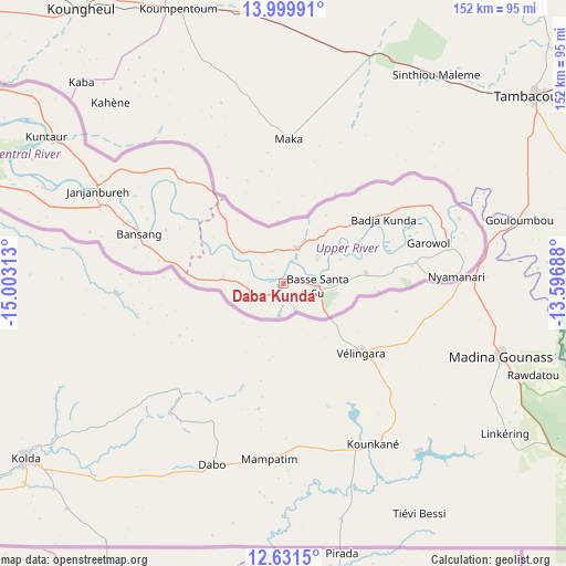
Daba Kunda GPS coordinates[2]
13° 19' 0.012" North, 14° 18' 0" West
| Map corner | latitude | longitude |
|---|---|---|
| Upper-left | 13.99991°, | -15.00313° |
| Center: | 13.31667°, | -14.3° |
| Lower-right: | 12.6315°, | -13.59688° |
| Map W x H: | 152.2×152.2 km | = 94.6×94.6mi |
| max Lat: | 13.8° ⇑87% North |
| Daba Kunda: | 13.31667° |
| min Lat: | ⇓13% South 13.20194° |
| min Long | Daba Kunda | max Long |
| -16.73389° | -14.3° | -13.85° |
| W 83.7%⇐ | ⇒16.3% E |
Elevation
Elevation of Daba Kunda is 20 m = 66 ft, and this is 1.1 m = 4 ft below average elevation for this country.
| Max E: |
49 m = 161 ft | 48.8% |
| Avg. | 21.1 m = 69 ft | |
| Daba Kunda | 20 m = 66 ft | |
Min E: |
1 m = 3 ft | 51.2% |
See also: Gambia elevation on elevation.city.
Geographical zone
Daba Kunda is located in North Torrid zone (between Equator and Tropic of Cancer). Distance of this Northern Tropic circle is 1125.2 km =699.2 mi to North.| Distance of | km | miles | from Daba Kunda |
|---|---|---|---|
| North Pole | 8526.4 | 5298.1 | to North |
| Arctic Circle | 5920.5 | 3678.8 | to North |
| Tropic Cancer | 1125.2 | 699.2 | to North |
| Equator | 1480.7 | 920.1 | to South |


Nearby cities:
15 places around Daba Kunda: (largest is in red/bold)
• Badari
21.7 km =13.5 mi,  85°
85°
• Bakadagy
9.2 km =5.7 mi,  258°
258°
• Banto Nding
28.8 km =17.9 mi,  54°
54°
• Basse Santa Su
9.4 km =5.8 mi, 94°
• Cha Kunda
26.3 km =16.3 mi,  286°
286°
• Demba Kunda
8.2 km =5.1 mi,  154°
154°
• Diabugu
13.1 km =8.1 mi,  304°
304°
• Giroba Kunda
11 km =6.8 mi,  99°
99°
• Jababa
9.1 km =5.7 mi,  307°
307°
• Kerewan
10.6 km =6.6 mi,  58°
58°
• Kumbija
13.8 km =8.6 mi,  113°
113°
• Perai
29.8 km =18.5 mi,  75°
75°
• Sabi
14.2 km =8.8 mi,  130°
130°
• Sanunding
20.2 km =12.6 mi, 100°
• Tuba-Wuli
14.1 km =8.8 mi,  22°
22°
Sources, notices
• [Note1] Compared only with cities in Gambia existing in our database
• [Src1] Map data: © OpenStreetMap contributors (CC-BY-SA)
• [Src2] Other city data from geonames.org with taken over terms of usage.
• [Src3] Geographical zone / Annual Mean Temperature by Robert A. Rohde @ Wikipedia
