Cha Kunda geodata
Cha Kunda (Central River) is a populated place; located in Gambia in Africa/Banjul (GMT+0) time zone. With population of 700 people, there are 96 cities with bigger population in this country. Compared to other cities in Gambia, 73.2% of cities are located further ↑North; 80.5% of cities are located further ←West and 61.8% of cities have lower elevation than Cha Kunda. Note1


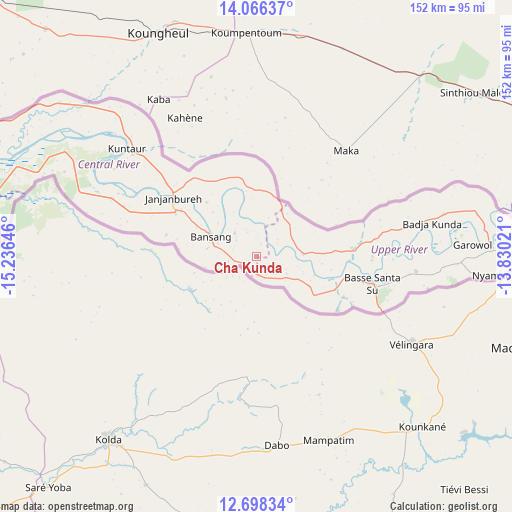
Cha Kunda GPS coordinates[2]
13° 22' 59.988" North, 14° 31' 59.988" West
| Map corner | latitude | longitude |
|---|---|---|
| Upper-left | 14.06637°, | -15.23646° |
| Center: | 13.38333°, | -14.53333° |
| Lower-right: | 12.69834°, | -13.83021° |
| Map W x H: | 152.1×152.1 km | = 94.5×94.5mi |
| max Lat: | 13.8° ⇑73.2% North |
| Cha Kunda: | 13.38333° |
| min Lat: | ⇓26.8% South 13.20194° |
| min Long | Cha Kunda | max Long |
| -16.73389° | -14.53333° | -13.85° |
| W 80.5%⇐ | ⇒19.5% E |
Elevation
Elevation of Cha Kunda is 23 m = 75 ft, and this is 1.9 m = 6 ft above average elevation for this country.
| Max E: |
49 m = 161 ft | 38.2% |
| Cha Kunda | 23 m 75 ft | |
| Avg. | 21.1 m = 69 ft | |
Min E: |
1 m = 3 ft | 61.8% |
See also: Gambia elevation on elevation.city.
Geographical zone
Cha Kunda is located in North Torrid zone (between Equator and Tropic of Cancer). Distance of this Northern Tropic circle is 1117.8 km =694.6 mi to North.| Distance of | km | miles | from Cha Kunda |
|---|---|---|---|
| North Pole | 8519 | 5293.5 | to North |
| Arctic Circle | 5913.1 | 3674.2 | to North |
| Tropic Cancer | 1117.8 | 694.6 | to North |
| Equator | 1488.1 | 924.7 | to South |


Nearby cities:
15 places around Cha Kunda: (largest is in red/bold)
• Bakadagy
18.7 km =11.6 mi,  119°
119°
• Bani
28.5 km =17.7 mi,  310°
310°
• Bansang
13.8 km =8.6 mi,  293°
293°
• Daba Kunda
26.3 km =16.3 mi,  106°
106°
• Demba Kunda
32.4 km =20.1 mi, 117°
• Diabugu
14.4 km =8.9 mi,  90°
90°
• Dobbo
14.2 km =8.8 mi, 310°
• Galleh Manda
27.6 km =17.1 mi,  281°
281°
• Georgetown
30.4 km =18.9 mi, 305°
• Jababa
18.1 km =11.2 mi,  95°
95°
• Kunting
22 km =13.7 mi,  319°
319°
• Madina Tunjang
24.1 km =15 mi, 283°
• Sulolor
16.2 km =10.1 mi,  297°
297°
• Tuba
18.7 km =11.6 mi, 299°
• Tuba-Wuli
31.1 km =19.3 mi,  79°
79°
Sources, notices
• [Note1] Compared only with cities in Gambia existing in our database
• [Src1] Map data: © OpenStreetMap contributors (CC-BY-SA)
• [Src2] Other city data from geonames.org with taken over terms of usage.
• [Src3] Geographical zone / Annual Mean Temperature by Robert A. Rohde @ Wikipedia
