Avliótes geodata
Avliótes (Ionian Islands) is a populated place; located in Greece in Europe/Athens (GMT+3) time zone. With population of 830 people, there are 1231 cities with bigger population in this country. Compared to other cities in Greece, 64.1% of cities are located further ↓South; 99.9% of cities are located further →East and 53.8% of cities have lower elevation than Avliótes. Note1


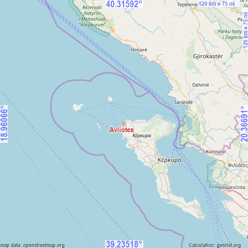
Avliótes GPS coordinates[2]
39° 46' 39.612" North, 19° 39' 49.608" East
| Map corner | latitude | longitude |
|---|---|---|
| Upper-left | 40.31592°, | 18.96066° |
| Center: | 39.77767°, | 19.66378° |
| Lower-right: | 39.23518°, | 20.36691° |
| Map W x H: | 120.2×120.2 km | = 74.7×74.7mi |
| max Lat: | 41.72048° ⇑35.9% North |
| Avliótes: | 39.77767° |
| min Lat: | ⇓64.1% South 34.8346° |
| min Long | Avliótes | max Long |
| 19.40494° | 19.66378° | 29.59361° |
| W 0.1%⇐ | ⇒99.9% E |
Elevation
Elevation of Avliótes is 95 m = 312 ft, and this is 73.9 m = 242 ft below average elevation for this country.
| Max E: |
1439 m = 4721 ft | 46.2% |
| Avg. | 168.9 m = 554 ft | |
| Avliótes | 95 m = 312 ft | |
Min E: |
0 m = 0 ft | 53.8% |
See also: Greece elevation on elevation.city.
Geographical zone
Avliótes is located in North temperate zone (between Tropic of Cancer and the Arctic Circle). Distance of this Northern Tropic circle is 1816.9 km =1129 mi to South.| Distance of | km | miles | from Avliótes |
|---|---|---|---|
| North Pole | 5584.2 | 3469.9 | to North |
| Arctic Circle | 2978.3 | 1850.6 | to North |
| Tropic Cancer | 1816.9 | 1129 | to South |
| Equator | 4422.9 | 2748.3 | to South |


Nearby cities:
15 places around Avliótes: (largest is in red/bold)
• Acharávi
13.2 km =8.2 mi,  82°
82°
• Agios Georgis
6.7 km =4.2 mi,  152°
152°
• Doukádes
11.8 km =7.3 mi, 145°
• Giannádes
18.4 km =11.4 mi, 152°
• Karousádes
6.9 km =4.3 mi,  87°
87°
• Kavvadádes
3.8 km =2.4 mi,  159°
159°
• Káto Agios Márkos
16.5 km =10.3 mi,  118°
118°
• Káto Korakiána
17.1 km =10.6 mi, 124°
• Liapádes
13.7 km =8.5 mi, 151°
• Nýmfes
10.6 km =6.6 mi,  103°
103°
• Perouládes
1.3 km =0.8 mi,  39°
39°
• Róda
11.1 km =6.9 mi, 84°
• Spartýlas
16.5 km =10.3 mi,  112°
112°
• Ypsos
17.4 km =10.8 mi, 121°
• Áno Korakiána
13.6 km =8.5 mi,  126°
126°
Sources, notices
• [Note1] Compared only with cities in Greece existing in our database
• [Src1] Map data: © OpenStreetMap contributors (CC-BY-SA)
• [Src2] Other city data from geonames.org with taken over terms of usage.
• [Src3] Geographical zone / Annual Mean Temperature by Robert A. Rohde @ Wikipedia
