Ístro geodata
Ístro (Crete) is a populated place; located in Greece in Europe/Athens (GMT+3) time zone. With population of 665 people, there are 1471 cities with bigger population in this country. Compared to other cities in Greece, 98.6% of cities are located further ↑North; 92% of cities are located further ←West and 78.7% of cities have higher elevation than Ístro. Note1


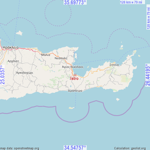
Ístro GPS coordinates[2]
35° 7' 28.848" North, 25° 44' 19.752" East
| Map corner | latitude | longitude |
|---|---|---|
| Upper-left | 35.69773°, | 25.0357° |
| Center: | 35.12468°, | 25.73882° |
| Lower-right: | 34.54757°, | 26.44195° |
| Map W x H: | 127.9×127.9 km | = 79.5×79.5mi |
| max Lat: | 41.72048° ⇑98.6% North |
| Ístro: | 35.12468° |
| min Lat: | ⇓1.4% South 34.8346° |
| min Long | Ístro | max Long |
| 19.40494° | 25.73882° | 29.59361° |
| W 92%⇐ | ⇒8% E |
Elevation
Elevation of Ístro is 19 m = 62 ft, and this is 149.9 m = 492 ft below average elevation for this country.
| Max E: |
1439 m = 4721 ft | 78.7% |
| Avg. | 168.9 m = 554 ft | |
| Ístro | 19 m = 62 ft | |
Min E: |
0 m = 0 ft | 21.3% |
See also: Greece elevation on elevation.city.
Geographical zone
Ístro is located in North temperate zone (between Tropic of Cancer and the Arctic Circle). Distance of this Northern Tropic circle is 1299.6 km =807.5 mi to South.| Distance of | km | miles | from Ístro |
|---|---|---|---|
| North Pole | 6101.6 | 3791.4 | to North |
| Arctic Circle | 3495.7 | 2172.1 | to North |
| Tropic Cancer | 1299.6 | 807.5 | to South |
| Equator | 3905.5 | 2426.8 | to South |


Nearby cities:
15 places around Ístro: (largest is in red/bold)
• Eloúnda
15.7 km =9.8 mi,  354°
354°
• Férma
15.7 km =9.8 mi,  138°
138°
• Gra Liyiá
13 km =8.1 mi,  199°
199°
• Ierápetra
12.5 km =7.8 mi,  178°
178°
• Kavoúsi
10.8 km =6.7 mi,  91°
91°
• Kentrí
10.3 km =6.4 mi,  172°
172°
• Koutsounári
14.7 km =9.1 mi,  145°
145°
• Kritsá
9.3 km =5.8 mi,  293°
293°
• Káto Chorió
9.7 km =6 mi, 150°
• Néa Anatolí
14.6 km =9.1 mi,  208°
208°
• Pacheía Ámmos
6.6 km =4.1 mi,  105°
105°
• Schísma Eloúndas
14.8 km =9.2 mi,  356°
356°
• Vaïniá
11.5 km =7.1 mi,  164°
164°
• Xirókambos
9.7 km =6 mi,  339°
339°
• Ágios Nikólaos
7.7 km =4.8 mi, 343°
Sources, notices
• [Note1] Compared only with cities in Greece existing in our database
• [Src1] Map data: © OpenStreetMap contributors (CC-BY-SA)
• [Src2] Other city data from geonames.org with taken over terms of usage.
• [Src3] Geographical zone / Annual Mean Temperature by Robert A. Rohde @ Wikipedia
