Cholargós geodata
Cholargós (Attica) is a seat of a third-order administrative division; located in Greece in Europe/Athens (GMT+3) time zone. With population of 30,840 people, there are 58 cities with bigger population in this country. Compared to other cities in Greece, 73.8% of cities are located further ↑North; 73.2% of cities are located further ←West and 75.8% of cities have lower elevation than Cholargós. Note1
Administrative division(s):
- Level 1: Attica
- Level 2: Nomarchía Athínas
- Level 3: Dimos Papagou-Cholargos


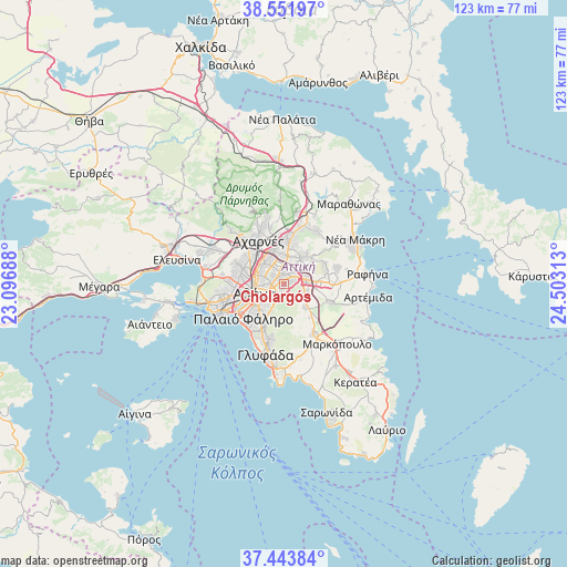
Cholargós GPS coordinates[2]
38° 0' 0" North, 23° 48' 0" East
| Map corner | latitude | longitude |
|---|---|---|
| Upper-left | 38.55197°, | 23.09688° |
| Center: | 38°, | 23.8° |
| Lower-right: | 37.44384°, | 24.50313° |
| Map W x H: | 123.2×123.2 km | = 76.6×76.6mi |
| max Lat: | 41.72048° ⇑73.8% North |
| Cholargós: | 38° |
| min Lat: | ⇓26.2% South 34.8346° |
| min Long | Cholargós | max Long |
| 19.40494° | 23.8° | 29.59361° |
| W 73.2%⇐ | ⇒26.8% E |
Elevation
Elevation of Cholargós is 219 m = 719 ft, and this is 50.1 m = 164 ft above average elevation for this country.
| Max E: |
1439 m = 4721 ft | 24.2% |
| Cholargós | 219 m 719 ft | |
| Avg. | 168.9 m = 554 ft | |
Min E: |
0 m = 0 ft | 75.8% |
See also: Greece elevation on elevation.city.
Geographical zone
Cholargós is located in North temperate zone (between Tropic of Cancer and the Arctic Circle). Distance of this Northern Tropic circle is 1619.3 km =1006.2 mi to South.| Distance of | km | miles | from Cholargós |
|---|---|---|---|
| North Pole | 5781.9 | 3592.7 | to North |
| Arctic Circle | 3176 | 1973.5 | to North |
| Tropic Cancer | 1619.3 | 1006.2 | to South |
| Equator | 4225.2 | 2625.4 | to South |


Nearby cities:
15 places around Cholargós: (largest is in red/bold)
• Agía Paraskeví
3.5 km =2.2 mi,  57°
57°
• Filothéi
3.2 km =2 mi,  331°
331°
• Galátsi
4.8 km =3 mi,  292°
292°
• Gérakas
5.6 km =3.5 mi, 63°
• Kaisarianí
5.1 km =3.2 mi,  216°
216°
• Khalándrion
2.6 km =1.6 mi,  1°
1°
• Kipséli
5.5 km =3.4 mi,  273°
273°
• Leondárion
5 km =3.1 mi,  106°
106°
• Maroúsi
5.6 km =3.5 mi, 0°
• Néa Ionía
5.5 km =3.4 mi,  316°
316°
• Néo Psychikó
1.6 km =1 mi,  295°
295°
• Papágou
1.6 km =1 mi,  200°
200°
• Psychikó
2.8 km =1.7 mi, 301°
• Vrilissia
4.6 km =2.9 mi,  34°
34°
• Zográfos
3.8 km =2.4 mi,  225°
225°
Sources, notices
• [Note1] Compared only with cities in Greece existing in our database
• [Src1] Map data: © OpenStreetMap contributors (CC-BY-SA)
• [Src2] Other city data from geonames.org with taken over terms of usage.
• [Src3] Geographical zone / Annual Mean Temperature by Robert A. Rohde @ Wikipedia
