Giánnouli geodata
Giánnouli (Thessaly) is a populated place; located in Greece in Europe/Athens (GMT+3) time zone. With population of 7,885 people, there are 168 cities with bigger population in this country. Compared to other cities in Greece, 62% of cities are located further ↓South; 62.8% of cities are located further →East and 51.7% of cities have higher elevation than Giánnouli. Note1


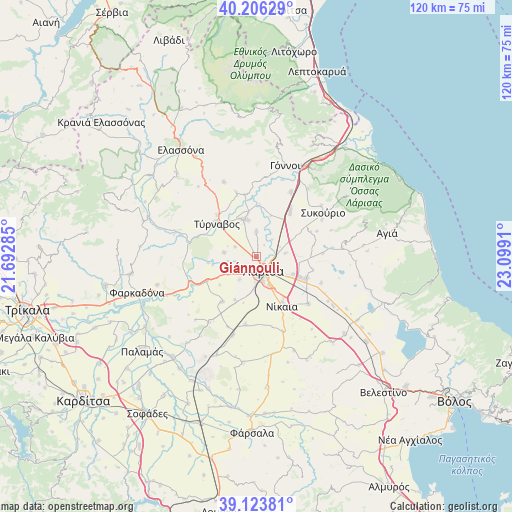
Giánnouli GPS coordinates[2]
39° 40' 1.812" North, 22° 23' 45.492" East
| Map corner | latitude | longitude |
|---|---|---|
| Upper-left | 40.20629°, | 21.69285° |
| Center: | 39.66717°, | 22.39597° |
| Lower-right: | 39.12381°, | 23.0991° |
| Map W x H: | 120.4×120.4 km | = 74.8×74.8mi |
| max Lat: | 41.72048° ⇑38% North |
| Giánnouli: | 39.66717° |
| min Lat: | ⇓62% South 34.8346° |
| min Long | Giánnouli | max Long |
| 19.40494° | 22.39597° | 29.59361° |
| W 37.2%⇐ | ⇒62.8% E |
Elevation
Elevation of Giánnouli is 75 m = 246 ft, and this is 93.9 m = 308 ft below average elevation for this country.
| Max E: |
1439 m = 4721 ft | 51.7% |
| Avg. | 168.9 m = 554 ft | |
| Giánnouli | 75 m = 246 ft | |
Min E: |
0 m = 0 ft | 48.3% |
See also: Greece elevation on elevation.city.
Geographical zone
Giánnouli is located in North temperate zone (between Tropic of Cancer and the Arctic Circle). Distance of this Northern Tropic circle is 1804.7 km =1121.4 mi to South.| Distance of | km | miles | from Giánnouli |
|---|---|---|---|
| North Pole | 5596.5 | 3477.5 | to North |
| Arctic Circle | 2990.6 | 1858.3 | to North |
| Tropic Cancer | 1804.7 | 1121.4 | to South |
| Equator | 4410.6 | 2740.6 | to South |


Nearby cities:
15 places around Giánnouli: (largest is in red/bold)
• Ampelóna
9 km =5.6 mi,  343°
343°
• Chálki
16.5 km =10.3 mi,  131°
131°
• Dasochóri
3.4 km =2.1 mi,  34°
34°
• Eleftherés
11.1 km =6.9 mi,  206°
206°
• Fálanna
5.9 km =3.7 mi,  1°
1°
• Koiláda
13.1 km =8.1 mi,  217°
217°
• Lárisa
3.8 km =2.4 mi,  151°
151°
• Makrychóri
16.6 km =10.3 mi, 26°
• Mándra
13 km =8.1 mi,  243°
243°
• Níkaia
12.7 km =7.9 mi, 151°
• Platýkampos
13 km =8.1 mi,  115°
115°
• Sykoúrio
18.8 km =11.7 mi,  56°
56°
• Terpsithéa
6.6 km =4.1 mi, 215°
• Týrnavos
12 km =7.5 mi,  310°
310°
• Óssa
17.9 km =11.1 mi, 60°
Sources, notices
• [Note1] Compared only with cities in Greece existing in our database
• [Src1] Map data: © OpenStreetMap contributors (CC-BY-SA)
• [Src2] Other city data from geonames.org with taken over terms of usage.
• [Src3] Geographical zone / Annual Mean Temperature by Robert A. Rohde @ Wikipedia
