Makrychóri geodata
Makrychóri (Thessaly) is a seat of a third-order administrative division; located in Greece in Europe/Athens (GMT+3) time zone. With population of 1,835 people, there are 563 cities with bigger population in this country. Compared to other cities in Greece, 64.7% of cities are located further ↓South; 60.4% of cities are located further →East and 68.1% of cities have lower elevation than Makrychóri. Note1


Makrychóri GPS coordinates[2]
39° 48' 0" North, 22° 28' 59.988" East
| Map corner | latitude | longitude |
|---|---|---|
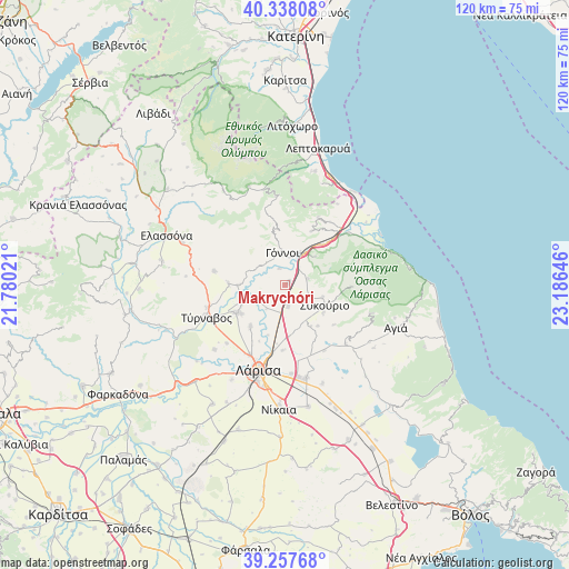
| Upper-left | 40.33808°, | 21.78021° |
| Center: | 39.8°, | 22.48333° |
| Lower-right: | 39.25768°, | 23.18646° |
| Map W x H: | 120.1×120.1 km | = 74.6×74.6mi |
| max Lat: | 41.72048° ⇑35.3% North |
| Makrychóri: | 39.8° |
| min Lat: | ⇓64.7% South 34.8346° |
| min Long | Makrychóri | max Long |
| 19.40494° | 22.48333° | 29.59361° |
| W 39.6%⇐ | ⇒60.4% E |
Elevation
Elevation of Makrychóri is 153 m = 502 ft, and this is 15.9 m = 52 ft below average elevation for this country.
| Max E: |
1439 m = 4721 ft | 31.9% |
| Avg. | 168.9 m = 554 ft | |
| Makrychóri | 153 m = 502 ft | |
Min E: |
0 m = 0 ft | 68.1% |
See also: Greece elevation on elevation.city.
Geographical zone
Makrychóri is located in North temperate zone (between Tropic of Cancer and the Arctic Circle). Distance of this Northern Tropic circle is 1819.4 km =1130.5 mi to South.| Distance of | km | miles | from Makrychóri |
|---|---|---|---|
| North Pole | 5581.7 | 3468.3 | to North |
| Arctic Circle | 2975.8 | 1849.1 | to North |
| Tropic Cancer | 1819.4 | 1130.5 | to South |
| Equator | 4425.3 | 2749.8 | to South |


Nearby cities:
15 places around Makrychóri: (largest is in red/bold)
• Ampelóna
11.8 km =7.3 mi,  238°
238°
• Argyropoúli
15.3 km =9.5 mi,  280°
280°
• Dasochóri
13.2 km =8.2 mi,  204°
204°
• Eláteia
4.9 km =3 mi,  75°
75°
• Fálanna
11.6 km =7.2 mi,  219°
219°
• Giánnouli
16.6 km =10.3 mi,  206°
206°
• Gónnoi
6.9 km =4.3 mi,  355°
355°
• Lárisa
19 km =11.8 mi, 197°
• Omólio
17.2 km =10.7 mi,  51°
51°
• Pournári
8.4 km =5.2 mi,  108°
108°
• Pyrgetós
16.2 km =10.1 mi,  35°
35°
• Rapsáni
12.7 km =7.9 mi,  26°
26°
• Sykoúrio
9.4 km =5.8 mi,  118°
118°
• Týrnavos
18 km =11.2 mi,  247°
247°
• Óssa
10.1 km =6.3 mi,  126°
126°
Sources, notices
• [Note1] Compared only with cities in Greece existing in our database
• [Src1] Map data: © OpenStreetMap contributors (CC-BY-SA)
• [Src2] Other city data from geonames.org with taken over terms of usage.
• [Src3] Geographical zone / Annual Mean Temperature by Robert A. Rohde @ Wikipedia
