Platýkampos geodata
Platýkampos (Thessaly) is a populated place; located in Greece in Europe/Athens (GMT+3) time zone. With population of 1,889 people, there are 552 cities with bigger population in this country. Compared to other cities in Greece, 60.3% of cities are located further ↓South; 59.4% of cities are located further →East and 54.8% of cities have higher elevation than Platýkampos. Note1


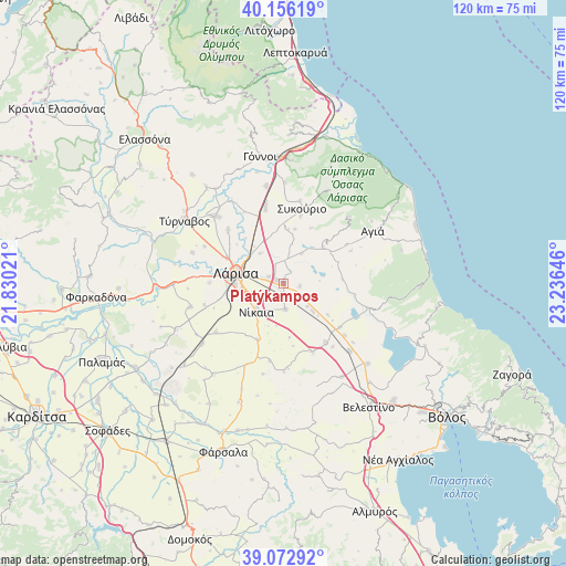
Platýkampos GPS coordinates[2]
39° 37' 0.012" North, 22° 31' 59.988" East
| Map corner | latitude | longitude |
|---|---|---|
| Upper-left | 40.15619°, | 21.83021° |
| Center: | 39.61667°, | 22.53333° |
| Lower-right: | 39.07292°, | 23.23646° |
| Map W x H: | 120.4×120.4 km | = 74.8×74.8mi |
| max Lat: | 41.72048° ⇑39.7% North |
| Platýkampos: | 39.61667° |
| min Lat: | ⇓60.3% South 34.8346° |
| min Long | Platýkampos | max Long |
| 19.40494° | 22.53333° | 29.59361° |
| W 40.6%⇐ | ⇒59.4% E |
Elevation
Elevation of Platýkampos is 66 m = 217 ft, and this is 102.9 m = 338 ft below average elevation for this country.
| Max E: |
1439 m = 4721 ft | 54.8% |
| Avg. | 168.9 m = 554 ft | |
| Platýkampos | 66 m = 217 ft | |
Min E: |
0 m = 0 ft | 45.2% |
See also: Greece elevation on elevation.city.
Geographical zone
Platýkampos is located in North temperate zone (between Tropic of Cancer and the Arctic Circle). Distance of this Northern Tropic circle is 1799 km =1117.8 mi to South.| Distance of | km | miles | from Platýkampos |
|---|---|---|---|
| North Pole | 5602.1 | 3481 | to North |
| Arctic Circle | 2996.2 | 1861.8 | to North |
| Tropic Cancer | 1799 | 1117.8 | to South |
| Equator | 4405 | 2737.1 | to South |


Nearby cities:
15 places around Platýkampos: (largest is in red/bold)
• Ampelóna
20.2 km =12.6 mi,  314°
314°
• Arméni
20.1 km =12.5 mi,  135°
135°
• Chálki
5.4 km =3.4 mi,  173°
173°
• Dasochóri
12.9 km =8 mi, 310°
• Eleftherés
17.3 km =10.7 mi,  255°
255°
• Fálanna
16.3 km =10.1 mi, 314°
• Giánnouli
13 km =8.1 mi,  295°
295°
• Koiláda
20.3 km =12.6 mi, 256°
• Lárisa
10.2 km =6.3 mi,  282°
282°
• Makrychóri
20.8 km =12.9 mi,  348°
348°
• Níkaia
8 km =5 mi,  225°
225°
• Pournári
18 km =11.2 mi,  11°
11°
• Sykoúrio
16.4 km =10.2 mi, 14°
• Terpsithéa
15.6 km =9.7 mi,  270°
270°
• Óssa
14.9 km =9.3 mi, 14°
Sources, notices
• [Note1] Compared only with cities in Greece existing in our database
• [Src1] Map data: © OpenStreetMap contributors (CC-BY-SA)
• [Src2] Other city data from geonames.org with taken over terms of usage.
• [Src3] Geographical zone / Annual Mean Temperature by Robert A. Rohde @ Wikipedia
