Goúves geodata
Goúves (Crete) is a populated place; located in Greece in Europe/Athens (GMT+3) time zone. With population of 539 people, there are 1719 cities with bigger population in this country. Compared to other cities in Greece, 96.4% of cities are located further ↑North; 89.3% of cities are located further ←West and 56.8% of cities have lower elevation than Goúves. Note1


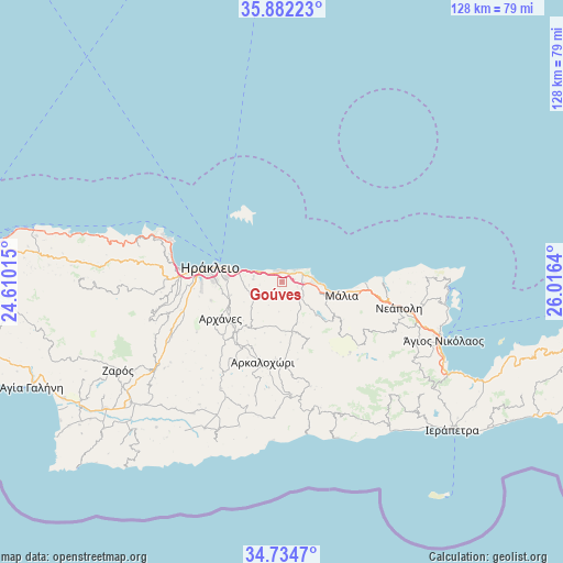
Goúves GPS coordinates[2]
35° 18' 37.8" North, 25° 18' 47.772" East
| Map corner | latitude | longitude |
|---|---|---|
| Upper-left | 35.88223°, | 24.61015° |
| Center: | 35.3105°, | 25.31327° |
| Lower-right: | 34.7347°, | 26.0164° |
| Map W x H: | 127.6×127.6 km | = 79.3×79.3mi |
| max Lat: | 41.72048° ⇑96.4% North |
| Goúves: | 35.3105° |
| min Lat: | ⇓3.6% South 34.8346° |
| min Long | Goúves | max Long |
| 19.40494° | 25.31327° | 29.59361° |
| W 89.3%⇐ | ⇒10.7% E |
Elevation
Elevation of Goúves is 104 m = 341 ft, and this is 64.9 m = 213 ft below average elevation for this country.
| Max E: |
1439 m = 4721 ft | 43.2% |
| Avg. | 168.9 m = 554 ft | |
| Goúves | 104 m = 341 ft | |
Min E: |
0 m = 0 ft | 56.8% |
See also: Greece elevation on elevation.city.
Geographical zone
Goúves is located in North temperate zone (between Tropic of Cancer and the Arctic Circle). Distance of this Northern Tropic circle is 1320.2 km =820.3 mi to South.| Distance of | km | miles | from Goúves |
|---|---|---|---|
| North Pole | 6080.9 | 3778.5 | to North |
| Arctic Circle | 3475 | 2159.3 | to North |
| Tropic Cancer | 1320.2 | 820.3 | to South |
| Equator | 3926.2 | 2439.6 | to South |


Nearby cities:
15 places around Goúves: (largest is in red/bold)
• Eliá
7.5 km =4.7 mi,  263°
263°
• Episkopí
9.1 km =5.7 mi,  229°
229°
• Goúrnes
3.7 km =2.3 mi,  298°
298°
• Karterós
9.9 km =6.2 mi,  282°
282°
• Kastélli
11.5 km =7.1 mi,  168°
168°
• Khersónisos
5.3 km =3.3 mi,  93°
93°
• Kokkíni Cháni
5.4 km =3.4 mi,  291°
291°
• Káto Goúves
2.1 km =1.3 mi,  0°
0°
• Limín Khersonísou
7.3 km =4.5 mi,  79°
79°
• Mokhós
11.3 km =7 mi,  117°
117°
• Mália
13.9 km =8.6 mi,  102°
102°
• Skalánion
11.9 km =7.4 mi,  254°
254°
• Stalís
11 km =6.8 mi, 100°
• Thrapsanón
13.9 km =8.6 mi,  192°
192°
• Vatheianós Kámpos
6.4 km =4 mi, 280°
Sources, notices
• [Note1] Compared only with cities in Greece existing in our database
• [Src1] Map data: © OpenStreetMap contributors (CC-BY-SA)
• [Src2] Other city data from geonames.org with taken over terms of usage.
• [Src3] Geographical zone / Annual Mean Temperature by Robert A. Rohde @ Wikipedia
