Selianítika geodata
Selianítika (West Greece) is a populated place; located in Greece in Europe/Athens (GMT+3) time zone. With population of 902 people, there are 1130 cities with bigger population in this country. Compared to other cities in Greece, 66.6% of cities are located further ↑North; 71.5% of cities are located further →East and 84.7% of cities have higher elevation than Selianítika. Note1


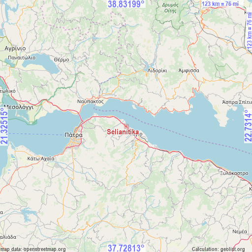
Selianítika GPS coordinates[2]
38° 16' 55.776" North, 22° 1' 41.772" East
| Map corner | latitude | longitude |
|---|---|---|
| Upper-left | 38.83199°, | 21.32515° |
| Center: | 38.28216°, | 22.02827° |
| Lower-right: | 37.72813°, | 22.7314° |
| Map W x H: | 122.7×122.7 km | = 76.2×76.2mi |
| max Lat: | 41.72048° ⇑66.6% North |
| Selianítika: | 38.28216° |
| min Lat: | ⇓33.4% South 34.8346° |
| min Long | Selianítika | max Long |
| 19.40494° | 22.02827° | 29.59361° |
| W 28.5%⇐ | ⇒71.5% E |
Elevation
Elevation of Selianítika is 13 m = 43 ft, and this is 155.9 m = 511 ft below average elevation for this country.
| Max E: |
1439 m = 4721 ft | 84.7% |
| Avg. | 168.9 m = 554 ft | |
| Selianítika | 13 m = 43 ft | |
Min E: |
0 m = 0 ft | 15.3% |
See also: Greece elevation on elevation.city.
Geographical zone
Selianítika is located in North temperate zone (between Tropic of Cancer and the Arctic Circle). Distance of this Northern Tropic circle is 1650.7 km =1025.7 mi to South.| Distance of | km | miles | from Selianítika |
|---|---|---|---|
| North Pole | 5750.5 | 3573.2 | to North |
| Arctic Circle | 3144.6 | 1954 | to North |
| Tropic Cancer | 1650.7 | 1025.7 | to South |
| Equator | 4256.6 | 2644.9 | to South |


Nearby cities:
15 places around Selianítika: (largest is in red/bold)
• Aktaío
20.6 km =12.8 mi,  276°
276°
• Antirrio
23.7 km =14.7 mi, 283°
• Aígio
6 km =3.7 mi,  128°
128°
• Drépano
16 km =9.9 mi,  285°
285°
• Kamárai
3.2 km =2 mi,  305°
305°
• Kastráki
18.9 km =11.7 mi,  322°
322°
• Káto Arachovítika
17 km =10.6 mi, 287°
• Lóngos
1.5 km =0.9 mi,  336°
336°
• Náfpaktos
21.3 km =13.2 mi,  304°
304°
• Psathópyrgos
14.4 km =8.9 mi, 290°
• Pátra
26 km =16.2 mi,  260°
260°
• Rododáfni
2.3 km =1.4 mi, 127°
• Río
21.3 km =13.2 mi,  274°
274°
• Témeni
9.8 km =6.1 mi,  120°
120°
• Áno Kastrítsi
16.8 km =10.4 mi, 266°
Sources, notices
• [Note1] Compared only with cities in Greece existing in our database
• [Src1] Map data: © OpenStreetMap contributors (CC-BY-SA)
• [Src2] Other city data from geonames.org with taken over terms of usage.
• [Src3] Geographical zone / Annual Mean Temperature by Robert A. Rohde @ Wikipedia
