Antirrio geodata
Antirrio (West Greece) is a populated place; located in Greece in Europe/Athens (GMT+3) time zone. With population of 1,018 people, there are 996 cities with bigger population in this country. Compared to other cities in Greece, 65.1% of cities are located further ↑North; 77.2% of cities are located further →East and 99.6% of cities have higher elevation than Antirrio. Note1
Administrative division(s):
- Level 1: West Greece
- Level 2: Nomós Aitolías kai Akarnanías
- Level 3: Dimos Nafpaktia


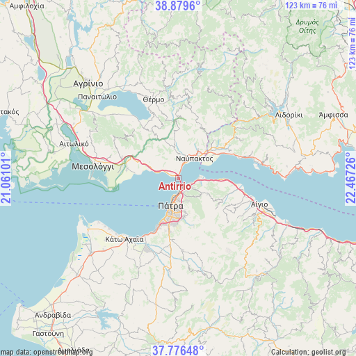
Antirrio GPS coordinates[2]
38° 19' 48.504" North, 21° 45' 50.868" East
| Map corner | latitude | longitude |
|---|---|---|
| Upper-left | 38.8796°, | 21.06101° |
| Center: | 38.33014°, | 21.76413° |
| Lower-right: | 37.77648°, | 22.46726° |
| Map W x H: | 122.7×122.7 km | = 76.2×76.2mi |
| max Lat: | 41.72048° ⇑65.1% North |
| Antirrio: | 38.33014° |
| min Lat: | ⇓34.9% South 34.8346° |
| min Long | Antirrio | max Long |
| 19.40494° | 21.76413° | 29.59361° |
| W 22.8%⇐ | ⇒77.2% E |
Elevation
Elevation of Antirrio is 1 m = 3 ft, and this is 167.9 m = 551 ft below average elevation for this country.
| Max E: |
1439 m = 4721 ft | 99.6% |
| Avg. | 168.9 m = 554 ft | |
| Antirrio | 1 m = 3 ft | |
Min E: |
0 m = 0 ft | 0.4% |
See also: Greece elevation on elevation.city.
Geographical zone
Antirrio is located in North temperate zone (between Tropic of Cancer and the Arctic Circle). Distance of this Northern Tropic circle is 1656 km =1029 mi to South.| Distance of | km | miles | from Antirrio |
|---|---|---|---|
| North Pole | 5745.1 | 3569.8 | to North |
| Arctic Circle | 3139.3 | 1950.7 | to North |
| Tropic Cancer | 1656 | 1029 | to South |
| Equator | 4261.9 | 2648.2 | to South |


Nearby cities:
15 places around Antirrio: (largest is in red/bold)
• Aktaío
3.9 km =2.4 mi,  137°
137°
• Drépano
7.7 km =4.8 mi,  97°
97°
• Galatás
17.9 km =11.1 mi,  279°
279°
• Kastráki
15 km =9.3 mi,  50°
50°
• Káto Arachovítika
6.8 km =4.2 mi,  91°
91°
• Mindilóglion
17.2 km =10.7 mi,  198°
198°
• Monodhéndrion
19 km =11.8 mi, 202°
• Náfpaktos
8.8 km =5.5 mi,  38°
38°
• Ovriá
16 km =9.9 mi,  191°
191°
• Paralía
15.6 km =9.7 mi, 200°
• Psathópyrgos
9.6 km =6 mi, 91°
• Pátra
9.9 km =6.2 mi, 195°
• Royítika
17.8 km =11.1 mi, 203°
• Río
4.3 km =2.7 mi,  154°
154°
• Áno Kastrítsi
9 km =5.6 mi, 135°
Sources, notices
• [Note1] Compared only with cities in Greece existing in our database
• [Src1] Map data: © OpenStreetMap contributors (CC-BY-SA)
• [Src2] Other city data from geonames.org with taken over terms of usage.
• [Src3] Geographical zone / Annual Mean Temperature by Robert A. Rohde @ Wikipedia
