Portariá geodata
Portariá (Thessaly) is a populated place; located in Greece in Europe/Athens (GMT+3) time zone. With population of 1,429 people, there are 705 cities with bigger population in this country. Compared to other cities in Greece, 53.6% of cities are located further ↓South; 54.9% of cities are located further ←West and 94.3% of cities have lower elevation than Portariá. Note1


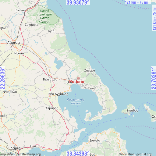
Portariá GPS coordinates[2]
39° 23' 22.2" North, 22° 59' 58.128" East
| Map corner | latitude | longitude |
|---|---|---|
| Upper-left | 39.93079°, | 22.29636° |
| Center: | 39.3895°, | 22.99948° |
| Lower-right: | 38.84398°, | 23.70261° |
| Map W x H: | 120.8×120.8 km | = 75.1×75.1mi |
| max Lat: | 41.72048° ⇑46.4% North |
| Portariá: | 39.3895° |
| min Lat: | ⇓53.6% South 34.8346° |
| min Long | Portariá | max Long |
| 19.40494° | 22.99948° | 29.59361° |
| W 54.9%⇐ | ⇒45.1% E |
Elevation
Elevation of Portariá is 640 m = 2100 ft, and this is 471.1 m = 1546 ft above average elevation for this country.
| Max E: |
1439 m = 4721 ft | 5.7% |
| Portariá | 640 m 2100 ft | |
| Avg. | 168.9 m = 554 ft | |
Min E: |
0 m = 0 ft | 94.3% |
See also: Greece elevation on elevation.city.
Geographical zone
Portariá is located in North temperate zone (between Tropic of Cancer and the Arctic Circle). Distance of this Northern Tropic circle is 1773.8 km =1102.2 mi to South.| Distance of | km | miles | from Portariá |
|---|---|---|---|
| North Pole | 5627.4 | 3496.7 | to North |
| Arctic Circle | 3021.5 | 1877.5 | to North |
| Tropic Cancer | 1773.8 | 1102.2 | to South |
| Equator | 4379.7 | 2721.4 | to South |


Nearby cities:
15 places around Portariá: (largest is in red/bold)
• Agriá
5.5 km =3.4 mi,  168°
168°
• Anakasiá
2.3 km =1.4 mi,  246°
246°
• Kalá Nerá
14 km =8.7 mi,  131°
131°
• Kanália
15.6 km =9.7 mi,  321°
321°
• Káto Lekhónia
7.4 km =4.6 mi,  152°
152°
• Makrinítsa
1.7 km =1.1 mi, 321°
• Miléai
14.8 km =9.2 mi,  117°
117°
• Néa Ionía
6.3 km =3.9 mi,  259°
259°
• Tsagkaráda
15 km =9.3 mi,  90°
90°
• Volos
5.8 km =3.6 mi,  237°
237°
• Zagorá
10.9 km =6.8 mi,  52°
52°
• Ágios Geórgios Ferón
19.2 km =11.9 mi, 263°
• Álli Meriá
2.5 km =1.6 mi,  212°
212°
• Áno Lekhónia
8.3 km =5.2 mi, 145°
• Áno Vólos
1.9 km =1.2 mi,  233°
233°
Sources, notices
• [Note1] Compared only with cities in Greece existing in our database
• [Src1] Map data: © OpenStreetMap contributors (CC-BY-SA)
• [Src2] Other city data from geonames.org with taken over terms of usage.
• [Src3] Geographical zone / Annual Mean Temperature by Robert A. Rohde @ Wikipedia
