Zagorá geodata
Zagorá (Thessaly) is a seat of a third-order administrative division; located in Greece in Europe/Athens (GMT+3) time zone. With population of 2,385 people, there are 438 cities with bigger population in this country. Compared to other cities in Greece, 55% of cities are located further ↓South; 57% of cities are located further ←West and 89% of cities have lower elevation than Zagorá. Note1
Administrative division(s):
- Level 1: Thessaly
- Level 2: Nomós Magnisías
- Level 3: Dimos Zagora-Mouresi


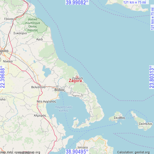
Zagorá GPS coordinates[2]
39° 27' 0" North, 23° 6' 0" East
| Map corner | latitude | longitude |
|---|---|---|
| Upper-left | 39.99082°, | 22.39688° |
| Center: | 39.45°, | 23.1° |
| Lower-right: | 38.90495°, | 23.80313° |
| Map W x H: | 120.7×120.7 km | = 75×75mi |
| max Lat: | 41.72048° ⇑45% North |
| Zagorá: | 39.45° |
| min Lat: | ⇓55% South 34.8346° |
| min Long | Zagorá | max Long |
| 19.40494° | 23.1° | 29.59361° |
| W 57%⇐ | ⇒43% E |
Elevation
Elevation of Zagorá is 487 m = 1598 ft, and this is 318.1 m = 1044 ft above average elevation for this country.
| Max E: |
1439 m = 4721 ft | 11% |
| Zagorá | 487 m 1598 ft | |
| Avg. | 168.9 m = 554 ft | |
Min E: |
0 m = 0 ft | 89% |
See also: Greece elevation on elevation.city.
Geographical zone
Zagorá is located in North temperate zone (between Tropic of Cancer and the Arctic Circle). Distance of this Northern Tropic circle is 1780.5 km =1106.4 mi to South.| Distance of | km | miles | from Zagorá |
|---|---|---|---|
| North Pole | 5620.6 | 3492.5 | to North |
| Arctic Circle | 3014.7 | 1873.2 | to North |
| Tropic Cancer | 1780.5 | 1106.4 | to South |
| Equator | 4386.4 | 2725.6 | to South |


Nearby cities:
15 places around Zagorá: (largest is in red/bold)
• Agriá
14.3 km =8.9 mi,  211°
211°
• Anakasiá
13.2 km =8.2 mi,  234°
234°
• Argalastí
26.9 km =16.7 mi,  157°
157°
• Kalá Nerá
16.1 km =10 mi,  173°
173°
• Kanália
19.2 km =11.9 mi,  286°
286°
• Káto Lekhónia
14.2 km =8.8 mi,  201°
201°
• Makrinítsa
11.1 km =6.9 mi,  240°
240°
• Miléai
14.4 km =8.9 mi, 161°
• Néa Ionía
16.8 km =10.4 mi, 241°
• Portariá
10.9 km =6.8 mi, 232°
• Tsagkaráda
9.3 km =5.8 mi,  137°
137°
• Volos
16.8 km =10.4 mi, 233°
• Álli Meriá
13.4 km =8.3 mi, 228°
• Áno Lekhónia
14.2 km =8.8 mi, 196°
• Áno Vólos
12.8 km =8 mi, 232°
Sources, notices
• [Note1] Compared only with cities in Greece existing in our database
• [Src1] Map data: © OpenStreetMap contributors (CC-BY-SA)
• [Src2] Other city data from geonames.org with taken over terms of usage.
• [Src3] Geographical zone / Annual Mean Temperature by Robert A. Rohde @ Wikipedia
