Anakasiá geodata
Anakasiá (Thessaly) is a populated place; located in Greece in Europe/Athens (GMT+3) time zone. With population of 1,012 people, there are 1004 cities with bigger population in this country. Compared to other cities in Greece, 53.5% of cities are located further ↓South; 53.8% of cities are located further ←West and 70.5% of cities have lower elevation than Anakasiá. Note1


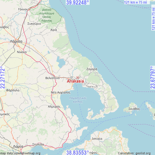
Anakasiá GPS coordinates[2]
39° 22' 52.032" North, 22° 58' 29.424" East
| Map corner | latitude | longitude |
|---|---|---|
| Upper-left | 39.92248°, | 22.27172° |
| Center: | 39.38112°, | 22.97484° |
| Lower-right: | 38.83553°, | 23.67797° |
| Map W x H: | 120.9×120.9 km | = 75.1×75.1mi |
| max Lat: | 41.72048° ⇑46.5% North |
| Anakasiá: | 39.38112° |
| min Lat: | ⇓53.5% South 34.8346° |
| min Long | Anakasiá | max Long |
| 19.40494° | 22.97484° | 29.59361° |
| W 53.8%⇐ | ⇒46.2% E |
Elevation
Elevation of Anakasiá is 169 m = 554 ft, and this is 0.099999999999994 m = 0 ft above average elevation for this country.
| Max E: |
1439 m = 4721 ft | 29.5% |
| Anakasiá | 169 m 554 ft | |
| Avg. | 168.9 m = 554 ft | |
Min E: |
0 m = 0 ft | 70.5% |
See also: Greece elevation on elevation.city.
Geographical zone
Anakasiá is located in North temperate zone (between Tropic of Cancer and the Arctic Circle). Distance of this Northern Tropic circle is 1772.9 km =1101.6 mi to South.| Distance of | km | miles | from Anakasiá |
|---|---|---|---|
| North Pole | 5628.3 | 3497.3 | to North |
| Arctic Circle | 3022.4 | 1878 | to North |
| Tropic Cancer | 1772.9 | 1101.6 | to South |
| Equator | 4378.8 | 2720.9 | to South |


Nearby cities:
15 places around Anakasiá: (largest is in red/bold)
• Agriá
5.5 km =3.4 mi,  144°
144°
• Kalá Nerá
15.1 km =9.4 mi,  123°
123°
• Kanália
15.2 km =9.4 mi,  329°
329°
• Káto Lekhónia
7.9 km =4.9 mi, 135°
• Makrinítsa
2.5 km =1.6 mi,  25°
25°
• Miléai
16.3 km =10.1 mi,  111°
111°
• Néa Ionía
4.1 km =2.5 mi,  266°
266°
• Portariá
2.3 km =1.4 mi,  66°
66°
• Tsagkaráda
17.1 km =10.6 mi,  87°
87°
• Volos
3.6 km =2.2 mi,  231°
231°
• Zagorá
13.2 km =8.2 mi,  54°
54°
• Ágios Geórgios Ferón
17 km =10.6 mi, 265°
• Álli Meriá
1.4 km =0.9 mi,  148°
148°
• Áno Lekhónia
9 km =5.6 mi,  131°
131°
• Áno Vólos
0.6 km =0.4 mi, 108°
Sources, notices
• [Note1] Compared only with cities in Greece existing in our database
• [Src1] Map data: © OpenStreetMap contributors (CC-BY-SA)
• [Src2] Other city data from geonames.org with taken over terms of usage.
• [Src3] Geographical zone / Annual Mean Temperature by Robert A. Rohde @ Wikipedia
