Mytilene geodata
Mytilene (North Aegean) is a seat of a first-order administrative division; located in Greece in Europe/Athens (GMT+3) time zone. With population of 28,322 people, there are 67 cities with bigger population in this country. Compared to other cities in Greece, 52.7% of cities are located further ↑North; 97.3% of cities are located further ←West and 83.9% of cities have higher elevation than Mytilene. Note1


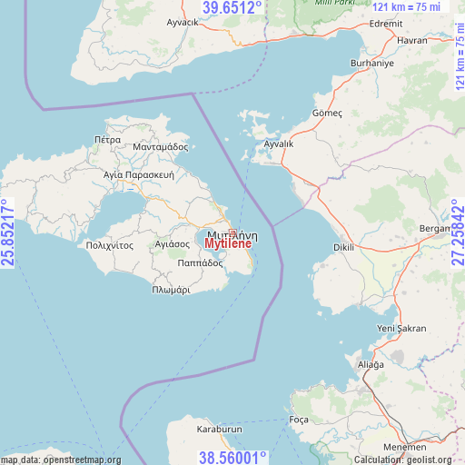
Mytilene GPS coordinates[2]
39° 6' 27.792" North, 26° 33' 19.044" East
| Map corner | latitude | longitude |
|---|---|---|
| Upper-left | 39.6512°, | 25.85217° |
| Center: | 39.10772°, | 26.55529° |
| Lower-right: | 38.56001°, | 27.25842° |
| Map W x H: | 121.3×121.3 km | = 75.4×75.4mi |
| max Lat: | 41.72048° ⇑52.7% North |
| Mytilene: | 39.10772° |
| min Lat: | ⇓47.3% South 34.8346° |
| min Long | Mytilene | max Long |
| 19.40494° | 26.55529° | 29.59361° |
| W 97.3%⇐ | ⇒2.7% E |
Elevation
Elevation of Mytilene is 14 m = 46 ft, and this is 154.9 m = 508 ft below average elevation for this country.
| Max E: |
1439 m = 4721 ft | 83.9% |
| Avg. | 168.9 m = 554 ft | |
| Mytilene | 14 m = 46 ft | |
Min E: |
0 m = 0 ft | 16.1% |
See also: Greece elevation on elevation.city.
Geographical zone
Mytilene is located in North temperate zone (between Tropic of Cancer and the Arctic Circle). Distance of this Northern Tropic circle is 1742.5 km =1082.7 mi to South.| Distance of | km | miles | from Mytilene |
|---|---|---|---|
| North Pole | 5658.7 | 3516.2 | to North |
| Arctic Circle | 3052.8 | 1896.9 | to North |
| Tropic Cancer | 1742.5 | 1082.7 | to South |
| Equator | 4348.4 | 2702 | to South |


Nearby cities:
15 places around Mytilene: (largest is in red/bold)
• Agiásos
16 km =9.9 mi,  260°
260°
• Agía Paraskeví
29 km =18 mi,  302°
302°
• Káto Trítos
10.8 km =6.7 mi, 257°
• Loutrá
5.7 km =3.5 mi,  189°
189°
• Mesagrós
12.4 km =7.7 mi,  230°
230°
• Mória
4.3 km =2.7 mi,  309°
309°
• Palaiókipos
10.7 km =6.6 mi,  237°
237°
• Panagioúda
4.9 km =3 mi,  332°
332°
• Pappádos
11.5 km =7.1 mi, 228°
• Plagiá
19.5 km =12.1 mi,  224°
224°
• Plomári
21.7 km =13.5 mi, 227°
• Pámfila
6.2 km =3.9 mi, 332°
• Pérama
8.4 km =5.2 mi,  211°
211°
• Skópelos
12.7 km =7.9 mi, 226°
• Vareiá
3.7 km =2.3 mi,  148°
148°
In other languages:
- In Spanish: Mitilene
- In France: Mytilène
- In German: Mytilini
- In Italian: Mitilene
- In Russian: Митилини
- In Chinese: 米蒂利尼
Sources, notices
• [Note1] Compared only with cities in Greece existing in our database
• [Src1] Map data: © OpenStreetMap contributors (CC-BY-SA)
• [Src2] Other city data from geonames.org with taken over terms of usage.
• [Src3] Geographical zone / Annual Mean Temperature by Robert A. Rohde @ Wikipedia
