Loutrá geodata
Loutrá (North Aegean) is a populated place; located in Greece in Europe/Athens (GMT+3) time zone. With population of 1,116 people, there are 903 cities with bigger population in this country. Compared to other cities in Greece, 53.8% of cities are located further ↑North; 97.2% of cities are located further ←West and 52.7% of cities have higher elevation than Loutrá. Note1


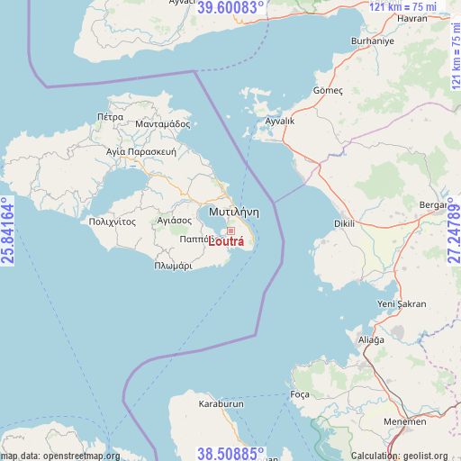
Loutrá GPS coordinates[2]
39° 3' 25.02" North, 26° 32' 41.136" East
| Map corner | latitude | longitude |
|---|---|---|
| Upper-left | 39.60083°, | 25.84164° |
| Center: | 39.05695°, | 26.54476° |
| Lower-right: | 38.50885°, | 27.24789° |
| Map W x H: | 121.4×121.4 km | = 75.4×75.4mi |
| max Lat: | 41.72048° ⇑53.8% North |
| Loutrá: | 39.05695° |
| min Lat: | ⇓46.2% South 34.8346° |
| min Long | Loutrá | max Long |
| 19.40494° | 26.54476° | 29.59361° |
| W 97.2%⇐ | ⇒2.8% E |
Elevation
Elevation of Loutrá is 72 m = 236 ft, and this is 96.9 m = 318 ft below average elevation for this country.
| Max E: |
1439 m = 4721 ft | 52.7% |
| Avg. | 168.9 m = 554 ft | |
| Loutrá | 72 m = 236 ft | |
Min E: |
0 m = 0 ft | 47.3% |
See also: Greece elevation on elevation.city.
Geographical zone
Loutrá is located in North temperate zone (between Tropic of Cancer and the Arctic Circle). Distance of this Northern Tropic circle is 1736.8 km =1079.2 mi to South.| Distance of | km | miles | from Loutrá |
|---|---|---|---|
| North Pole | 5664.3 | 3519.6 | to North |
| Arctic Circle | 3058.4 | 1900.4 | to North |
| Tropic Cancer | 1736.8 | 1079.2 | to South |
| Equator | 4342.7 | 2698.4 | to South |


Nearby cities:
15 places around Loutrá: (largest is in red/bold)
• Agiásos
15.2 km =9.4 mi,  280°
280°
• Káto Trítos
10.2 km =6.3 mi,  288°
288°
• Mesagrós
8.9 km =5.5 mi,  255°
255°
• Mytilene
5.7 km =3.5 mi,  9°
9°
• Mória
8.7 km =5.4 mi,  344°
344°
• Palaiókipos
8.1 km =5 mi,  268°
268°
• Panagioúda
10.1 km =6.3 mi,  352°
352°
• Pappádos
7.9 km =4.9 mi, 255°
• Plagiá
15.2 km =9.4 mi,  237°
237°
• Plomári
17.5 km =10.9 mi, 238°
• Pámfila
11.3 km =7 mi, 349°
• Pérama
3.8 km =2.4 mi,  246°
246°
• Skópelos
8.9 km =5.5 mi, 249°
• Vareiá
3.8 km =2.4 mi,  48°
48°
• Vrísa
29.7 km =18.5 mi, 266°
Sources, notices
• [Note1] Compared only with cities in Greece existing in our database
• [Src1] Map data: © OpenStreetMap contributors (CC-BY-SA)
• [Src2] Other city data from geonames.org with taken over terms of usage.
• [Src3] Geographical zone / Annual Mean Temperature by Robert A. Rohde @ Wikipedia
