Melissourgoí geodata
Melissourgoí (Epirus) is a populated place; located in Greece in Europe/Athens (GMT+3) time zone. With population of 593 people, there are 1597 cities with bigger population in this country. Compared to other cities in Greece, 56.7% of cities are located further ↓South; 88.4% of cities are located further →East and 98.5% of cities have lower elevation than Melissourgoí. Note1


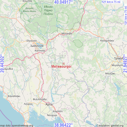
Melissourgoí GPS coordinates[2]
39° 30' 31.716" North, 21° 8' 46.104" East
| Map corner | latitude | longitude |
|---|---|---|
| Upper-left | 40.04917°, | 20.44302° |
| Center: | 39.50881°, | 21.14614° |
| Lower-right: | 38.96422°, | 21.84927° |
| Map W x H: | 120.6×120.6 km | = 74.9×74.9mi |
| max Lat: | 41.72048° ⇑43.3% North |
| Melissourgoí: | 39.50881° |
| min Lat: | ⇓56.7% South 34.8346° |
| min Long | Melissourgoí | max Long |
| 19.40494° | 21.14614° | 29.59361° |
| W 11.6%⇐ | ⇒88.4% E |
Elevation
Elevation of Melissourgoí is 885 m = 2904 ft, and this is 716.1 m = 2349 ft above average elevation for this country.
| Max E: |
1439 m = 4721 ft | 1.5% |
| Melissourgoí | 885 m 2904 ft | |
| Avg. | 168.9 m = 554 ft | |
Min E: |
0 m = 0 ft | 98.5% |
See also: Greece elevation on elevation.city.
Geographical zone
Melissourgoí is located in North temperate zone (between Tropic of Cancer and the Arctic Circle). Distance of this Northern Tropic circle is 1787 km =1110.4 mi to South.| Distance of | km | miles | from Melissourgoí |
|---|---|---|---|
| North Pole | 5614.1 | 3488.4 | to North |
| Arctic Circle | 3008.2 | 1869.2 | to North |
| Tropic Cancer | 1787 | 1110.4 | to South |
| Equator | 4393 | 2729.7 | to South |


Nearby cities:
15 places around Melissourgoí: (largest is in red/bold)
• Agía Kyriakí
22.6 km =14 mi,  273°
273°
• Anatolí
27.8 km =17.3 mi,  300°
300°
• Báfra
25.3 km =15.7 mi,  293°
293°
• Drosochóri
19.9 km =12.4 mi,  311°
311°
• Iliókali
19.5 km =12.1 mi, 308°
• Kastrítsa
23.5 km =14.6 mi, 305°
• Katsikás
25.5 km =15.8 mi, 299°
• Koutselió
21.9 km =13.6 mi, 293°
• Longádes
24.4 km =15.2 mi, 313°
• Neokaisáreia
24.8 km =15.4 mi, 290°
• Pediní
27.9 km =17.3 mi, 291°
• Prámanta
4.2 km =2.6 mi, 292°
• Theodóriana
9.9 km =6.2 mi,  146°
146°
• Voulgaréli
15.5 km =9.6 mi,  168°
168°
• Ágnanta
6.8 km =4.2 mi,  235°
235°
Sources, notices
• [Note1] Compared only with cities in Greece existing in our database
• [Src1] Map data: © OpenStreetMap contributors (CC-BY-SA)
• [Src2] Other city data from geonames.org with taken over terms of usage.
• [Src3] Geographical zone / Annual Mean Temperature by Robert A. Rohde @ Wikipedia
