Voulgaréli geodata
Voulgaréli (Epirus) is a seat of a third-order administrative division; located in Greece in Europe/Athens (GMT+3) time zone. With population of 590 people, there are 1602 cities with bigger population in this country. Compared to other cities in Greece, 53.2% of cities are located further ↓South; 88% of cities are located further →East and 97.1% of cities have lower elevation than Voulgaréli. Note1


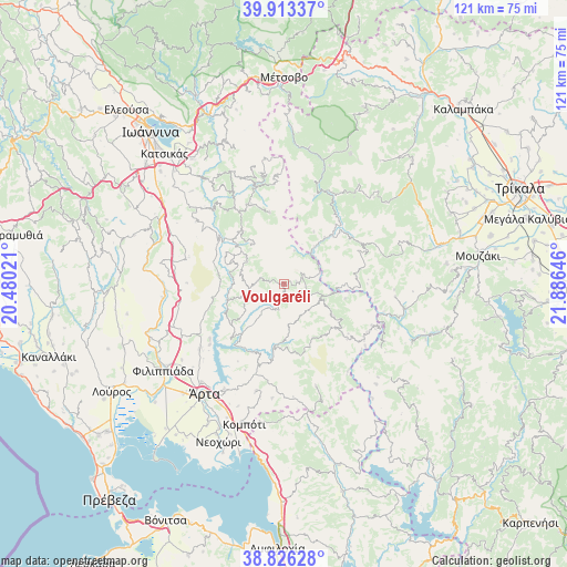
Voulgaréli GPS coordinates[2]
39° 22' 18.984" North, 21° 10' 59.988" East
| Map corner | latitude | longitude |
|---|---|---|
| Upper-left | 39.91337°, | 20.48021° |
| Center: | 39.37194°, | 21.18333° |
| Lower-right: | 38.82628°, | 21.88646° |
| Map W x H: | 120.9×120.9 km | = 75.1×75.1mi |
| max Lat: | 41.72048° ⇑46.8% North |
| Voulgaréli: | 39.37194° |
| min Lat: | ⇓53.2% South 34.8346° |
| min Long | Voulgaréli | max Long |
| 19.40494° | 21.18333° | 29.59361° |
| W 12%⇐ | ⇒88% E |
Elevation
Elevation of Voulgaréli is 779 m = 2556 ft, and this is 610.1 m = 2002 ft above average elevation for this country.
| Max E: |
1439 m = 4721 ft | 2.9% |
| Voulgaréli | 779 m 2556 ft | |
| Avg. | 168.9 m = 554 ft | |
Min E: |
0 m = 0 ft | 97.1% |
See also: Greece elevation on elevation.city.
Geographical zone
Voulgaréli is located in North temperate zone (between Tropic of Cancer and the Arctic Circle). Distance of this Northern Tropic circle is 1771.8 km =1100.9 mi to South.| Distance of | km | miles | from Voulgaréli |
|---|---|---|---|
| North Pole | 5629.3 | 3497.9 | to North |
| Arctic Circle | 3023.4 | 1878.7 | to North |
| Tropic Cancer | 1771.8 | 1100.9 | to South |
| Equator | 4377.7 | 2720.2 | to South |


Nearby cities:
15 places around Voulgaréli: (largest is in red/bold)
• Ammótopos
23.6 km =14.7 mi,  241°
241°
• Anthiró
23.8 km =14.8 mi,  96°
96°
• Grammenítsa
27.3 km =17 mi,  220°
220°
• Gymnótopos
25.7 km =16 mi,  249°
249°
• Megárchi
27.9 km =17.3 mi,  200°
200°
• Melissourgoí
15.5 km =9.6 mi,  348°
348°
• Prámanta
18.2 km =11.3 mi,  337°
337°
• Péta
26.2 km =16.3 mi,  209°
209°
• Pétra
23.7 km =14.7 mi,  194°
194°
• Stournaraíïka
27.8 km =17.3 mi,  71°
71°
• Theodóriana
7.4 km =4.6 mi,  17°
17°
• Ágioi Anárgyroi
29.2 km =18.1 mi, 207°
• Ágnanta
14.4 km =8.9 mi,  322°
322°
• Áno Kalentíni
13.6 km =8.5 mi,  179°
179°
• Árta
29.1 km =18.1 mi, 215°
Sources, notices
• [Note1] Compared only with cities in Greece existing in our database
• [Src1] Map data: © OpenStreetMap contributors (CC-BY-SA)
• [Src2] Other city data from geonames.org with taken over terms of usage.
• [Src3] Geographical zone / Annual Mean Temperature by Robert A. Rohde @ Wikipedia
