Marmárion geodata
Marmárion (Central Greece) is a populated place; located in Greece in Europe/Athens (GMT+3) time zone. With population of 1,013 people, there are 1002 cities with bigger population in this country. Compared to other cities in Greece, 71.6% of cities are located further ↑North; 82.1% of cities are located further ←West and 92.5% of cities have higher elevation than Marmárion. Note1


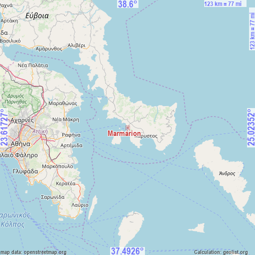
Marmárion GPS coordinates[2]
38° 2' 54.204" North, 24° 19' 13.404" East
| Map corner | latitude | longitude |
|---|---|---|
| Upper-left | 38.6°, | 23.61727° |
| Center: | 38.04839°, | 24.32039° |
| Lower-right: | 37.4926°, | 25.02352° |
| Map W x H: | 123.1×123.1 km | = 76.5×76.5mi |
| max Lat: | 41.72048° ⇑71.6% North |
| Marmárion: | 38.04839° |
| min Lat: | ⇓28.4% South 34.8346° |
| min Long | Marmárion | max Long |
| 19.40494° | 24.32039° | 29.59361° |
| W 82.1%⇐ | ⇒17.9% E |
Elevation
Elevation of Marmárion is 7 m = 23 ft, and this is 161.9 m = 531 ft below average elevation for this country.
| Max E: |
1439 m = 4721 ft | 92.5% |
| Avg. | 168.9 m = 554 ft | |
| Marmárion | 7 m = 23 ft | |
Min E: |
0 m = 0 ft | 7.5% |
See also: Greece elevation on elevation.city.
Geographical zone
Marmárion is located in North temperate zone (between Tropic of Cancer and the Arctic Circle). Distance of this Northern Tropic circle is 1624.7 km =1009.5 mi to South.| Distance of | km | miles | from Marmárion |
|---|---|---|---|
| North Pole | 5776.5 | 3589.3 | to North |
| Arctic Circle | 3170.6 | 1970.1 | to North |
| Tropic Cancer | 1624.7 | 1009.5 | to South |
| Equator | 4230.6 | 2628.8 | to South |


Nearby cities:
15 places around Marmárion: (largest is in red/bold)
• Aghios Panteleímon
30.6 km =19 mi,  284°
284°
• Agia Kyriakií Spáton
30.6 km =19 mi,  258°
258°
• Artémida
29.7 km =18.5 mi,  252°
252°
• Kallitechnoúpoli
31.9 km =19.8 mi,  265°
265°
• Kárystos
9.2 km =5.7 mi,  114°
114°
• Káto Soúlion
29.7 km =18.5 mi,  296°
296°
• Limín Mesoyaías
32.9 km =20.4 mi,  237°
237°
• Marathónas
33.4 km =20.8 mi,  290°
290°
• Neos Voutzás
30 km =18.6 mi, 268°
• Neápoli Spáton
31.3 km =19.4 mi, 252°
• Néa Mákri
30.4 km =18.9 mi, 278°
• Néa Stíra
17.5 km =10.9 mi,  326°
326°
• Rafína
27.7 km =17.2 mi, 263°
• Vraná
33.3 km =20.7 mi, 284°
• Zárakes
30.3 km =18.8 mi,  338°
338°
Sources, notices
• [Note1] Compared only with cities in Greece existing in our database
• [Src1] Map data: © OpenStreetMap contributors (CC-BY-SA)
• [Src2] Other city data from geonames.org with taken over terms of usage.
• [Src3] Geographical zone / Annual Mean Temperature by Robert A. Rohde @ Wikipedia
