Rafína geodata
Rafína (Attica) is a seat of a third-order administrative division; located in Greece in Europe/Athens (GMT+3) time zone. With population of 12,168 people, there are 126 cities with bigger population in this country. Compared to other cities in Greece, 72.9% of cities are located further ↑North; 78.8% of cities are located further ←West and 86.6% of cities have higher elevation than Rafína. Note1
Administrative division(s):
- Level 1: Attica
- Level 2: Nomarchía Anatolikís Attikís
- Level 3: Dimos Rafina-Pikermi


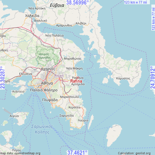
Rafína GPS coordinates[2]
38° 1' 5.232" North, 24° 0' 21.564" East
| Map corner | latitude | longitude |
|---|---|---|
| Upper-left | 38.56996°, | 23.30287° |
| Center: | 38.01812°, | 24.00599° |
| Lower-right: | 37.4621°, | 24.70912° |
| Map W x H: | 123.2×123.2 km | = 76.6×76.6mi |
| max Lat: | 41.72048° ⇑72.9% North |
| Rafína: | 38.01812° |
| min Lat: | ⇓27.1% South 34.8346° |
| min Long | Rafína | max Long |
| 19.40494° | 24.00599° | 29.59361° |
| W 78.8%⇐ | ⇒21.2% E |
Elevation
Elevation of Rafína is 11 m = 36 ft, and this is 157.9 m = 518 ft below average elevation for this country.
| Max E: |
1439 m = 4721 ft | 86.6% |
| Avg. | 168.9 m = 554 ft | |
| Rafína | 11 m = 36 ft | |
Min E: |
0 m = 0 ft | 13.4% |
See also: Greece elevation on elevation.city.
Geographical zone
Rafína is located in North temperate zone (between Tropic of Cancer and the Arctic Circle). Distance of this Northern Tropic circle is 1621.3 km =1007.4 mi to South.| Distance of | km | miles | from Rafína |
|---|---|---|---|
| North Pole | 5779.8 | 3591.4 | to North |
| Arctic Circle | 3174 | 1972.2 | to North |
| Tropic Cancer | 1621.3 | 1007.4 | to South |
| Equator | 4227.2 | 2626.7 | to South |


Nearby cities:
15 places around Rafína: (largest is in red/bold)
• Aghios Panteleímon
11.1 km =6.9 mi,  349°
349°
• Agia Kyriakií Spáton
3.7 km =2.3 mi,  221°
221°
• Anthoúsa
11.4 km =7.1 mi,  274°
274°
• Argithéa
11.6 km =7.2 mi,  245°
245°
• Artémida
5.7 km =3.5 mi,  188°
188°
• Christoúpoli
8.9 km =5.5 mi,  240°
240°
• Dhráfi
8.6 km =5.3 mi, 274°
• Dióni
6.4 km =4 mi,  275°
275°
• Kallitechnoúpoli
4.3 km =2.7 mi, 282°
• Neos Voutzás
3.7 km =2.3 mi,  318°
318°
• Neápoli Spáton
6.3 km =3.9 mi,  202°
202°
• Néa Mákri
8.1 km =5 mi,  341°
341°
• Pallíni
10.9 km =6.8 mi,  262°
262°
• Pikérmi
6 km =3.7 mi, 252°
• Spáta
10.1 km =6.3 mi,  231°
231°
Sources, notices
• [Note1] Compared only with cities in Greece existing in our database
• [Src1] Map data: © OpenStreetMap contributors (CC-BY-SA)
• [Src2] Other city data from geonames.org with taken over terms of usage.
• [Src3] Geographical zone / Annual Mean Temperature by Robert A. Rohde @ Wikipedia
