Skoutáros geodata
Skoutáros (North Aegean) is a populated place; located in Greece in Europe/Athens (GMT+3) time zone. With population of 881 people, there are 1157 cities with bigger population in this country. Compared to other cities in Greece, 51.1% of cities are located further ↓South; 94.2% of cities are located further ←West and 67% of cities have lower elevation than Skoutáros. Note1


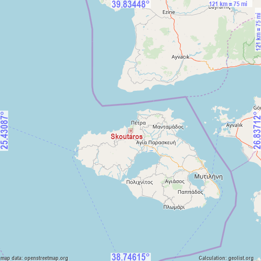
Skoutáros GPS coordinates[2]
39° 17' 32.748" North, 26° 8' 2.364" East
| Map corner | latitude | longitude |
|---|---|---|
| Upper-left | 39.83448°, | 25.43087° |
| Center: | 39.29243°, | 26.13399° |
| Lower-right: | 38.74615°, | 26.83712° |
| Map W x H: | 121×121 km | = 75.2×75.2mi |
| max Lat: | 41.72048° ⇑48.9% North |
| Skoutáros: | 39.29243° |
| min Lat: | ⇓51.1% South 34.8346° |
| min Long | Skoutáros | max Long |
| 19.40494° | 26.13399° | 29.59361° |
| W 94.2%⇐ | ⇒5.8% E |
Elevation
Elevation of Skoutáros is 147 m = 482 ft, and this is 21.9 m = 72 ft below average elevation for this country.
| Max E: |
1439 m = 4721 ft | 33% |
| Avg. | 168.9 m = 554 ft | |
| Skoutáros | 147 m = 482 ft | |
Min E: |
0 m = 0 ft | 67% |
See also: Greece elevation on elevation.city.
Geographical zone
Skoutáros is located in North temperate zone (between Tropic of Cancer and the Arctic Circle). Distance of this Northern Tropic circle is 1763 km =1095.5 mi to South.| Distance of | km | miles | from Skoutáros |
|---|---|---|---|
| North Pole | 5638.2 | 3503.4 | to North |
| Arctic Circle | 3032.3 | 1884.2 | to North |
| Tropic Cancer | 1763 | 1095.5 | to South |
| Equator | 4368.9 | 2714.7 | to South |


Nearby cities:
15 places around Skoutáros: (largest is in red/bold)
• Agía Paraskeví
12.9 km =8 mi,  112°
112°
• Dáfia
7.9 km =4.9 mi,  134°
134°
• Fília
3.4 km =2.1 mi,  170°
170°
• Kalloní
9.1 km =5.7 mi,  136°
136°
• Kerámion
10.6 km =6.6 mi, 143°
• Kápi
15.9 km =9.9 mi,  73°
73°
• Mantamádos
17.5 km =10.9 mi,  83°
83°
• Míthymna
9.1 km =5.7 mi,  23°
23°
• Parákoila
13.7 km =8.5 mi,  177°
177°
• Pétra
5.3 km =3.3 mi,  43°
43°
• Skalokhóri
6.3 km =3.9 mi,  233°
233°
• Stýpsi
7.7 km =4.8 mi, 74°
• Vatoússa
10.3 km =6.4 mi,  223°
223°
• Ágra
16.2 km =10.1 mi,  202°
202°
• Ántissa
14.7 km =9.1 mi,  243°
243°
Sources, notices
• [Note1] Compared only with cities in Greece existing in our database
• [Src1] Map data: © OpenStreetMap contributors (CC-BY-SA)
• [Src2] Other city data from geonames.org with taken over terms of usage.
• [Src3] Geographical zone / Annual Mean Temperature by Robert A. Rohde @ Wikipedia
