Korakovoúni geodata
Korakovoúni (Peloponnese) is a populated place; located in Greece in Europe/Athens (GMT+3) time zone. With population of 710 people, there are 1401 cities with bigger population in this country. Compared to other cities in Greece, 87.4% of cities are located further ↑North; 53.5% of cities are located further →East and 58.7% of cities have higher elevation than Korakovoúni. Note1
Administrative division(s):
- Level 1: Peloponnese
- Level 2: Nomós Arkadías
- Level 3: Dimos North Kynouria


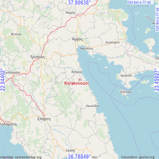
Korakovoúni GPS coordinates[2]
37° 20' 58.272" North, 22° 44' 49.704" East
| Map corner | latitude | longitude |
|---|---|---|
| Upper-left | 37.90638°, | 22.04402° |
| Center: | 37.34952°, | 22.74714° |
| Lower-right: | 36.78849°, | 23.45027° |
| Map W x H: | 124.3×124.3 km | = 77.2×77.2mi |
| max Lat: | 41.72048° ⇑87.4% North |
| Korakovoúni: | 37.34952° |
| min Lat: | ⇓12.6% South 34.8346° |
| min Long | Korakovoúni | max Long |
| 19.40494° | 22.74714° | 29.59361° |
| W 46.5%⇐ | ⇒53.5% E |
Elevation
Elevation of Korakovoúni is 54 m = 177 ft, and this is 114.9 m = 377 ft below average elevation for this country.
| Max E: |
1439 m = 4721 ft | 58.7% |
| Avg. | 168.9 m = 554 ft | |
| Korakovoúni | 54 m = 177 ft | |
Min E: |
0 m = 0 ft | 41.3% |
See also: Greece elevation on elevation.city.
Geographical zone
Korakovoúni is located in North temperate zone (between Tropic of Cancer and the Arctic Circle). Distance of this Northern Tropic circle is 1547 km =961.3 mi to South.| Distance of | km | miles | from Korakovoúni |
|---|---|---|---|
| North Pole | 5854.2 | 3637.6 | to North |
| Arctic Circle | 3248.3 | 2018.4 | to North |
| Tropic Cancer | 1547 | 961.3 | to South |
| Equator | 4152.9 | 2580.5 | to South |


Nearby cities:
15 places around Korakovoúni: (largest is in red/bold)
• Aria
26.1 km =16.2 mi,  17°
17°
• Asíni
24 km =14.9 mi,  25°
25°
• Drépanon
24.7 km =15.3 mi, 31°
• Karyés
22.7 km =14.1 mi,  253°
253°
• Kivéri
19.4 km =12.1 mi,  355°
355°
• Lefkákia
25.4 km =15.8 mi, 23°
• Leonídio
22.6 km =14 mi,  154°
154°
• Mýloi
22.8 km =14.2 mi,  353°
353°
• Náfplio
24.9 km =15.5 mi,  12°
12°
• Paralía Tyroú
14.9 km =9.3 mi,  138°
138°
• Parálio Ástros
7.6 km =4.7 mi, 12°
• Tolón
21.4 km =13.3 mi, 27°
• Ágios Andréas
1.6 km =1 mi,  107°
107°
• Ágios Pétros
17.9 km =11.1 mi,  262°
262°
• Ástros
6.5 km =4 mi,  339°
339°
Sources, notices
• [Note1] Compared only with cities in Greece existing in our database
• [Src1] Map data: © OpenStreetMap contributors (CC-BY-SA)
• [Src2] Other city data from geonames.org with taken over terms of usage.
• [Src3] Geographical zone / Annual Mean Temperature by Robert A. Rohde @ Wikipedia
