Drépanon geodata
Drépanon (Peloponnese) is a populated place; located in Greece in Europe/Athens (GMT+3) time zone. With population of 1,272 people, there are 794 cities with bigger population in this country. Compared to other cities in Greece, 85.6% of cities are located further ↑North; 51.6% of cities are located further ←West and 87.7% of cities have higher elevation than Drépanon. Note1


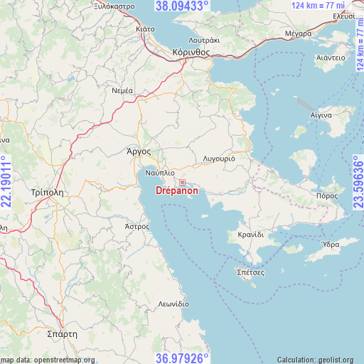
Drépanon GPS coordinates[2]
37° 32' 19.968" North, 22° 53' 35.628" East
| Map corner | latitude | longitude |
|---|---|---|
| Upper-left | 38.09433°, | 22.19011° |
| Center: | 37.53888°, | 22.89323° |
| Lower-right: | 36.97926°, | 23.59636° |
| Map W x H: | 124×124 km | = 77.1×77.1mi |
| max Lat: | 41.72048° ⇑85.6% North |
| Drépanon: | 37.53888° |
| min Lat: | ⇓14.4% South 34.8346° |
| min Long | Drépanon | max Long |
| 19.40494° | 22.89323° | 29.59361° |
| W 51.6%⇐ | ⇒48.4% E |
Elevation
Elevation of Drépanon is 10 m = 33 ft, and this is 158.9 m = 521 ft below average elevation for this country.
| Max E: |
1439 m = 4721 ft | 87.7% |
| Avg. | 168.9 m = 554 ft | |
| Drépanon | 10 m = 33 ft | |
Min E: |
0 m = 0 ft | 12.3% |
See also: Greece elevation on elevation.city.
Geographical zone
Drépanon is located in North temperate zone (between Tropic of Cancer and the Arctic Circle). Distance of this Northern Tropic circle is 1568 km =974.3 mi to South.| Distance of | km | miles | from Drépanon |
|---|---|---|---|
| North Pole | 5833.1 | 3624.5 | to North |
| Arctic Circle | 3227.2 | 2005.3 | to North |
| Tropic Cancer | 1568 | 974.3 | to South |
| Equator | 4173.9 | 2593.5 | to South |


Nearby cities:
15 places around Drépanon: (largest is in red/bold)
• Argolikón
12.2 km =7.6 mi,  317°
317°
• Aria
6.4 km =4 mi,  307°
307°
• Asíni
2.6 km =1.6 mi,  283°
283°
• Ayía Triás
13.4 km =8.3 mi, 324°
• Dhalamanára
14 km =8.7 mi, 309°
• Lefkákia
3.7 km =2.3 mi, 309°
• Láloukas
13.8 km =8.6 mi, 315°
• Metókhion
9 km =5.6 mi,  31°
31°
• Náfplio
8.3 km =5.2 mi,  293°
293°
• Néa Kíos
14.4 km =8.9 mi, 293°
• Néa Tírins
10 km =6.2 mi, 319°
• Panarítis
11.9 km =7.4 mi,  329°
329°
• Poullakídha
14.1 km =8.8 mi, 330°
• Tolón
3.7 km =2.3 mi,  235°
235°
• Áyios Adhrianós
8 km =5 mi, 328°
Sources, notices
• [Note1] Compared only with cities in Greece existing in our database
• [Src1] Map data: © OpenStreetMap contributors (CC-BY-SA)
• [Src2] Other city data from geonames.org with taken over terms of usage.
• [Src3] Geographical zone / Annual Mean Temperature by Robert A. Rohde @ Wikipedia
