Leonídio geodata
Leonídio (Peloponnese) is a seat of a third-order administrative division; located in Greece in Europe/Athens (GMT+3) time zone. With population of 3,020 people, there are 346 cities with bigger population in this country. Compared to other cities in Greece, 88.1% of cities are located further ↑North; 50.2% of cities are located further ←West and 67.6% of cities have higher elevation than Leonídio. Note1
Administrative division(s):
- Level 1: Peloponnese
- Level 2: Nomós Arkadías
- Level 3: Dimos South Kynouria


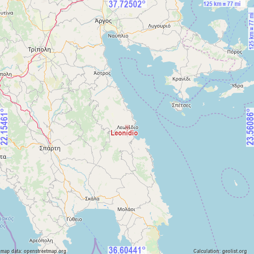
Leonídio GPS coordinates[2]
37° 10' 0.444" North, 22° 51' 27.828" East
| Map corner | latitude | longitude |
|---|---|---|
| Upper-left | 37.72502°, | 22.15461° |
| Center: | 37.16679°, | 22.85773° |
| Lower-right: | 36.60441°, | 23.56086° |
| Map W x H: | 124.6×124.6 km | = 77.4×77.4mi |
| max Lat: | 41.72048° ⇑88.1% North |
| Leonídio: | 37.16679° |
| min Lat: | ⇓11.9% South 34.8346° |
| min Long | Leonídio | max Long |
| 19.40494° | 22.85773° | 29.59361° |
| W 50.2%⇐ | ⇒49.8% E |
Elevation
Elevation of Leonídio is 35 m = 115 ft, and this is 133.9 m = 439 ft below average elevation for this country.
| Max E: |
1439 m = 4721 ft | 67.6% |
| Avg. | 168.9 m = 554 ft | |
| Leonídio | 35 m = 115 ft | |
Min E: |
0 m = 0 ft | 32.4% |
See also: Greece elevation on elevation.city.
Geographical zone
Leonídio is located in North temperate zone (between Tropic of Cancer and the Arctic Circle). Distance of this Northern Tropic circle is 1526.6 km =948.6 mi to South.| Distance of | km | miles | from Leonídio |
|---|---|---|---|
| North Pole | 5874.5 | 3650.2 | to North |
| Arctic Circle | 3268.6 | 2031 | to North |
| Tropic Cancer | 1526.6 | 948.6 | to South |
| Equator | 4132.6 | 2567.9 | to South |


Nearby cities:
15 places around Leonídio: (largest is in red/bold)
• Geráki
23.6 km =14.7 mi,  214°
214°
• Karyés
34.5 km =21.4 mi,  293°
293°
• Koilás
36.1 km =22.4 mi,  40°
40°
• Korakovoúni
22.6 km =14 mi,  334°
334°
• Kranídi
35.7 km =22.2 mi,  48°
48°
• Káto Glykóvrysi
38.4 km =23.9 mi,  190°
190°
• Paralía Tyroú
9.1 km =5.7 mi,  0°
0°
• Parálio Ástros
28.9 km =18 mi,  343°
343°
• Poúlithra
6.9 km =4.3 mi,  158°
158°
• Pórto Chéli
31 km =19.3 mi, 54°
• Spétses
28.7 km =17.8 mi,  68°
68°
• Vlachiótis
36.5 km =22.7 mi,  201°
201°
• Ágios Andréas
21.5 km =13.4 mi, 337°
• Ágios Pétros
32.9 km =20.4 mi,  303°
303°
• Ástros
29 km =18 mi, 335°
Sources, notices
• [Note1] Compared only with cities in Greece existing in our database
• [Src1] Map data: © OpenStreetMap contributors (CC-BY-SA)
• [Src2] Other city data from geonames.org with taken over terms of usage.
• [Src3] Geographical zone / Annual Mean Temperature by Robert A. Rohde @ Wikipedia
