Frágko geodata
Frágko (Thessaly) is a populated place; located in Greece in Europe/Athens (GMT+3) time zone. With population of 513 people, there are 1784 cities with bigger population in this country. Compared to other cities in Greece, 52.7% of cities are located further ↓South; 75.2% of cities are located further →East and 61.5% of cities have lower elevation than Frágko. Note1


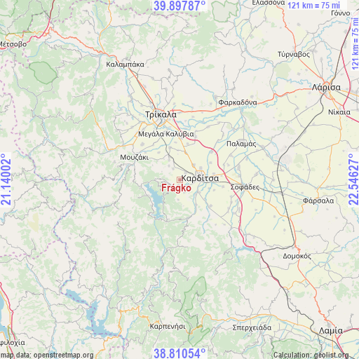
Frágko GPS coordinates[2]
39° 21' 22.752" North, 21° 50' 35.304" East
| Map corner | latitude | longitude |
|---|---|---|
| Upper-left | 39.89787°, | 21.14002° |
| Center: | 39.35632°, | 21.84314° |
| Lower-right: | 38.81054°, | 22.54627° |
| Map W x H: | 120.9×120.9 km | = 75.1×75.1mi |
| max Lat: | 41.72048° ⇑47.3% North |
| Frágko: | 39.35632° |
| min Lat: | ⇓52.7% South 34.8346° |
| min Long | Frágko | max Long |
| 19.40494° | 21.84314° | 29.59361° |
| W 24.8%⇐ | ⇒75.2% E |
Elevation
Elevation of Frágko is 124 m = 407 ft, and this is 44.9 m = 147 ft below average elevation for this country.
| Max E: |
1439 m = 4721 ft | 38.5% |
| Avg. | 168.9 m = 554 ft | |
| Frágko | 124 m = 407 ft | |
Min E: |
0 m = 0 ft | 61.5% |
See also: Greece elevation on elevation.city.
Geographical zone
Frágko is located in North temperate zone (between Tropic of Cancer and the Arctic Circle). Distance of this Northern Tropic circle is 1770.1 km =1099.9 mi to South.| Distance of | km | miles | from Frágko |
|---|---|---|---|
| North Pole | 5631 | 3498.9 | to North |
| Arctic Circle | 3025.2 | 1879.8 | to North |
| Tropic Cancer | 1770.1 | 1099.9 | to South |
| Equator | 4376 | 2719.1 | to South |


Nearby cities:
15 places around Frágko: (largest is in red/bold)
• Artesianó
6.8 km =4.2 mi,  42°
42°
• Fanári
7.6 km =4.7 mi,  330°
330°
• Georgikó
3.1 km =1.9 mi,  147°
147°
• Kanália
6 km =3.7 mi,  321°
321°
• Karditsomagoúla
7.9 km =4.9 mi,  61°
61°
• Kardítsa
6.8 km =4.2 mi,  82°
82°
• Krýa Vrýsi
4.5 km =2.8 mi,  144°
144°
• Mavrika
8.6 km =5.3 mi,  100°
100°
• Mitrópoli
2 km =1.2 mi,  194°
194°
• Morfovoúni
8 km =5 mi,  266°
266°
• Palaiokklísi
2.9 km =1.8 mi, 38°
• Rizovoúni
9.4 km =5.8 mi,  12°
12°
• Roússo
7.2 km =4.5 mi,  133°
133°
• Xinonéri
4.5 km =2.8 mi,  160°
160°
• Ágios Geórgios
6.7 km =4.2 mi, 185°
Sources, notices
• [Note1] Compared only with cities in Greece existing in our database
• [Src1] Map data: © OpenStreetMap contributors (CC-BY-SA)
• [Src2] Other city data from geonames.org with taken over terms of usage.
• [Src3] Geographical zone / Annual Mean Temperature by Robert A. Rohde @ Wikipedia
