Fíkhtion geodata
Fíkhtion (Peloponnese) is a populated place; located in Greece in Europe/Athens (GMT+3) time zone. With population of 761 people, there are 1316 cities with bigger population in this country. Compared to other cities in Greece, 82.3% of cities are located further ↑North; 54.5% of cities are located further →East and 54% of cities have lower elevation than Fíkhtion. Note1
Administrative division(s):
- Level 1: Peloponnese
- Level 2: Nomós Argolídos
- Level 3: Dimos Argos-Mykines


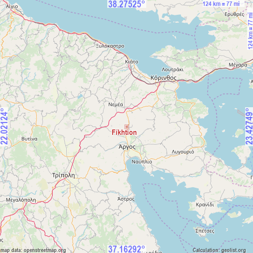
Fíkhtion GPS coordinates[2]
37° 43' 16.212" North, 22° 43' 27.696" East
| Map corner | latitude | longitude |
|---|---|---|
| Upper-left | 38.27525°, | 22.02124° |
| Center: | 37.72117°, | 22.72436° |
| Lower-right: | 37.16292°, | 23.42749° |
| Map W x H: | 123.7×123.7 km | = 76.9×76.9mi |
| max Lat: | 41.72048° ⇑82.3% North |
| Fíkhtion: | 37.72117° |
| min Lat: | ⇓17.7% South 34.8346° |
| min Long | Fíkhtion | max Long |
| 19.40494° | 22.72436° | 29.59361° |
| W 45.5%⇐ | ⇒54.5% E |
Elevation
Elevation of Fíkhtion is 96 m = 315 ft, and this is 72.9 m = 239 ft below average elevation for this country.
| Max E: |
1439 m = 4721 ft | 46% |
| Avg. | 168.9 m = 554 ft | |
| Fíkhtion | 96 m = 315 ft | |
Min E: |
0 m = 0 ft | 54% |
See also: Greece elevation on elevation.city.
Geographical zone
Fíkhtion is located in North temperate zone (between Tropic of Cancer and the Arctic Circle). Distance of this Northern Tropic circle is 1588.3 km =986.9 mi to South.| Distance of | km | miles | from Fíkhtion |
|---|---|---|---|
| North Pole | 5812.9 | 3612 | to North |
| Arctic Circle | 3207 | 1992.7 | to North |
| Tropic Cancer | 1588.3 | 986.9 | to South |
| Equator | 4194.2 | 2606.2 | to South |


Nearby cities:
15 places around Fíkhtion: (largest is in red/bold)
• Anífion
8.9 km =5.5 mi,  140°
140°
• ArchaÍes Kleonés
11.5 km =7.1 mi,  11°
11°
• Argolikón
13 km =8.1 mi,  149°
149°
• Ayía Triás
11.7 km =7.3 mi, 142°
• Dhalamanára
12.1 km =7.5 mi,  160°
160°
• Koutsopódi
4.2 km =2.6 mi,  193°
193°
• Láloukas
11.6 km =7.2 mi, 152°
• Mánesis
11.2 km =7 mi,  127°
127°
• Neméa
12.4 km =7.7 mi,  333°
333°
• Panarítis
13.3 km =8.3 mi, 138°
• Poullakídha
11.3 km =7 mi, 135°
• Prósimna
10.3 km =6.4 mi,  95°
95°
• Árgos
9.8 km =6.1 mi,  175°
175°
• Áyios Vasílios
10.6 km =6.6 mi,  37°
37°
• Ínachos
6.7 km =4.2 mi, 160°
Sources, notices
• [Note1] Compared only with cities in Greece existing in our database
• [Src1] Map data: © OpenStreetMap contributors (CC-BY-SA)
• [Src2] Other city data from geonames.org with taken over terms of usage.
• [Src3] Geographical zone / Annual Mean Temperature by Robert A. Rohde @ Wikipedia
