Fáros geodata
Fáros (Central Greece) is a populated place; located in Greece in Europe/Athens (GMT+3) time zone. With population of 1,171 people, there are 850 cities with bigger population in this country. Compared to other cities in Greece, 63.9% of cities are located further ↑North; 67.3% of cities are located further ←West and 90.7% of cities have higher elevation than Fáros. Note1


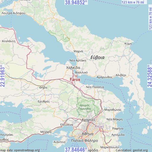
Fáros GPS coordinates[2]
38° 23' 58.524" North, 23° 37' 21.9" East
| Map corner | latitude | longitude |
|---|---|---|
| Upper-left | 38.94852°, | 22.91963° |
| Center: | 38.39959°, | 23.62275° |
| Lower-right: | 37.84646°, | 24.32588° |
| Map W x H: | 122.5×122.5 km | = 76.1×76.1mi |
| max Lat: | 41.72048° ⇑63.9% North |
| Fáros: | 38.39959° |
| min Lat: | ⇓36.1% South 34.8346° |
| min Long | Fáros | max Long |
| 19.40494° | 23.62275° | 29.59361° |
| W 67.3%⇐ | ⇒32.7% E |
Elevation
Elevation of Fáros is 8 m = 26 ft, and this is 160.9 m = 528 ft below average elevation for this country.
| Max E: |
1439 m = 4721 ft | 90.7% |
| Avg. | 168.9 m = 554 ft | |
| Fáros | 8 m = 26 ft | |
Min E: |
0 m = 0 ft | 9.3% |
See also: Greece elevation on elevation.city.
Geographical zone
Fáros is located in North temperate zone (between Tropic of Cancer and the Arctic Circle). Distance of this Northern Tropic circle is 1663.7 km =1033.8 mi to South.| Distance of | km | miles | from Fáros |
|---|---|---|---|
| North Pole | 5737.4 | 3565.1 | to North |
| Arctic Circle | 3131.5 | 1945.8 | to North |
| Tropic Cancer | 1663.7 | 1033.8 | to South |
| Equator | 4269.6 | 2653 | to South |


Nearby cities:
15 places around Fáros: (largest is in red/bold)
• Afrátion
8.1 km =5 mi,  44°
44°
• Chalkída
7.3 km =4.5 mi,  346°
346°
• Dílesi
8.1 km =5 mi,  148°
148°
• Fílla
7 km =4.3 mi,  48°
48°
• Kalochóri - Panteíchi
2.7 km =1.7 mi,  241°
241°
• Mikrón Vathí
5.2 km =3.2 mi,  330°
330°
• Mytikas
5.6 km =3.5 mi,  28°
28°
• Néa Lámpsakos
4.2 km =2.6 mi,  6°
6°
• Paralía Avlídhos
2.2 km =1.4 mi,  167°
167°
• Paralía Vathéos
1.9 km =1.2 mi,  335°
335°
• Pláka Dílesi
6.1 km =3.8 mi,  156°
156°
• Schimatári
6.5 km =4 mi,  211°
211°
• Vasilikón
5.2 km =3.2 mi,  55°
55°
• Vathí
1.8 km =1.1 mi,  289°
289°
• Áyios Nikólaos
3.2 km =2 mi, 43°
Sources, notices
• [Note1] Compared only with cities in Greece existing in our database
• [Src1] Map data: © OpenStreetMap contributors (CC-BY-SA)
• [Src2] Other city data from geonames.org with taken over terms of usage.
• [Src3] Geographical zone / Annual Mean Temperature by Robert A. Rohde @ Wikipedia
