Áyios Nikólaos geodata
Áyios Nikólaos (Central Greece) is a populated place; located in Greece in Europe/Athens (GMT+3) time zone. With population of 3,426 people, there are 312 cities with bigger population in this country. Compared to other cities in Greece, 63.2% of cities are located further ↑North; 68% of cities are located further ←West and 90.7% of cities have higher elevation than Áyios Nikólaos. Note1


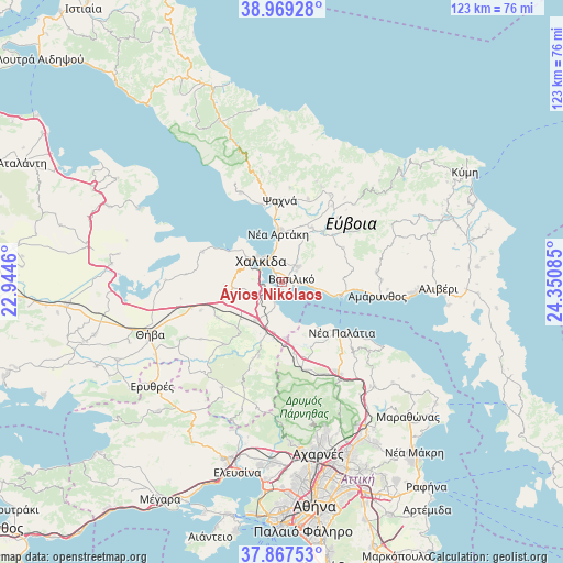
Áyios Nikólaos GPS coordinates[2]
38° 25' 13.836" North, 23° 38' 51.792" East
| Map corner | latitude | longitude |
|---|---|---|
| Upper-left | 38.96928°, | 22.9446° |
| Center: | 38.42051°, | 23.64772° |
| Lower-right: | 37.86753°, | 24.35085° |
| Map W x H: | 122.5×122.5 km | = 76.1×76.1mi |
| max Lat: | 41.72048° ⇑63.2% North |
| Áyios Nikólaos: | 38.42051° |
| min Lat: | ⇓36.8% South 34.8346° |
| min Long | Áyios Nikólao | max Long |
| 19.40494° | 23.64772° | 29.59361° |
| W 68%⇐ | ⇒32% E |
Elevation
Elevation of Áyios Nikólaos is 8 m = 26 ft, and this is 160.9 m = 528 ft below average elevation for this country.
| Max E: |
1439 m = 4721 ft | 90.7% |
| Avg. | 168.9 m = 554 ft | |
| Áyios Nikólaos | 8 m = 26 ft | |
Min E: |
0 m = 0 ft | 9.3% |
See also: Greece elevation on elevation.city.
Geographical zone
Áyios Nikólaos is located in North temperate zone (between Tropic of Cancer and the Arctic Circle). Distance of this Northern Tropic circle is 1666 km =1035.2 mi to South.| Distance of | km | miles | from Áyios Nikólaos |
|---|---|---|---|
| North Pole | 5735.1 | 3563.6 | to North |
| Arctic Circle | 3129.2 | 1944.4 | to North |
| Tropic Cancer | 1666 | 1035.2 | to South |
| Equator | 4272 | 2654.5 | to South |


Nearby cities:
15 places around Áyios Nikólaos: (largest is in red/bold)
• Afrátion
5 km =3.1 mi,  44°
44°
• Chalkída
6.2 km =3.9 mi,  320°
320°
• Dílesi
9.4 km =5.8 mi,  167°
167°
• Fáros
3.2 km =2 mi,  223°
223°
• Fílla
3.9 km =2.4 mi,  52°
52°
• Kalochóri - Panteíchi
5.8 km =3.6 mi,  231°
231°
• Ksyróvrisi
8.2 km =5.1 mi,  306°
306°
• Mikrón Vathí
5.3 km =3.3 mi,  294°
294°
• Mytikas
2.6 km =1.6 mi,  11°
11°
• Néa Lámpsakos
2.5 km =1.6 mi, 317°
• Paralía Avlídhos
4.8 km =3 mi,  200°
200°
• Paralía Vathéos
3 km =1.9 mi,  259°
259°
• Pláka Dílesi
7.9 km =4.9 mi,  178°
178°
• Vasilikón
2.2 km =1.4 mi,  74°
74°
• Vathí
4.2 km =2.6 mi,  245°
245°
Sources, notices
• [Note1] Compared only with cities in Greece existing in our database
• [Src1] Map data: © OpenStreetMap contributors (CC-BY-SA)
• [Src2] Other city data from geonames.org with taken over terms of usage.
• [Src3] Geographical zone / Annual Mean Temperature by Robert A. Rohde @ Wikipedia
