Vasilikón geodata
Vasilikón (Central Greece) is a populated place; located in Greece in Europe/Athens (GMT+3) time zone. With population of 6,571 people, there are 193 cities with bigger population in this country. Compared to other cities in Greece, 63.1% of cities are located further ↑North; 69% of cities are located further ←West and 71.4% of cities have higher elevation than Vasilikón. Note1


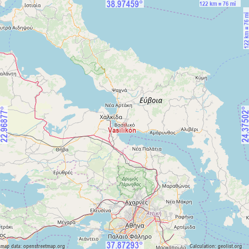
Vasilikón GPS coordinates[2]
38° 25' 33.096" North, 23° 40' 18.804" East
| Map corner | latitude | longitude |
|---|---|---|
| Upper-left | 38.97459°, | 22.96877° |
| Center: | 38.42586°, | 23.67189° |
| Lower-right: | 37.87293°, | 24.37502° |
| Map W x H: | 122.5×122.5 km | = 76.1×76.1mi |
| max Lat: | 41.72048° ⇑63.1% North |
| Vasilikón: | 38.42586° |
| min Lat: | ⇓36.9% South 34.8346° |
| min Long | Vasilikón | max Long |
| 19.40494° | 23.67189° | 29.59361° |
| W 69%⇐ | ⇒31% E |
Elevation
Elevation of Vasilikón is 29 m = 95 ft, and this is 139.9 m = 459 ft below average elevation for this country.
| Max E: |
1439 m = 4721 ft | 71.4% |
| Avg. | 168.9 m = 554 ft | |
| Vasilikón | 29 m = 95 ft | |
Min E: |
0 m = 0 ft | 28.6% |
See also: Greece elevation on elevation.city.
Geographical zone
Vasilikón is located in North temperate zone (between Tropic of Cancer and the Arctic Circle). Distance of this Northern Tropic circle is 1666.6 km =1035.6 mi to South.| Distance of | km | miles | from Vasilikón |
|---|---|---|---|
| North Pole | 5734.5 | 3563.3 | to North |
| Arctic Circle | 3128.6 | 1944 | to North |
| Tropic Cancer | 1666.6 | 1035.6 | to South |
| Equator | 4272.6 | 2654.9 | to South |


Nearby cities:
15 places around Vasilikón: (largest is in red/bold)
• Afrátion
3.2 km =2 mi,  25°
25°
• Chalkída
7.3 km =4.5 mi,  304°
304°
• Fáros
5.2 km =3.2 mi,  235°
235°
• Fílla
2 km =1.2 mi, 28°
• Kalochóri - Panteíchi
7.8 km =4.8 mi, 237°
• Ksyróvrisi
9.7 km =6 mi, 296°
• Malakónta
8.7 km =5.4 mi,  109°
109°
• Mikrón Vathí
7.1 km =4.4 mi,  283°
283°
• Mytikas
2.5 km =1.6 mi,  321°
321°
• Néa Lámpsakos
4 km =2.5 mi,  288°
288°
• Paralía Avlídhos
6.4 km =4 mi,  216°
216°
• Paralía Vathéos
5.2 km =3.2 mi,  257°
257°
• Pláka Dílesi
8.7 km =5.4 mi,  192°
192°
• Vathí
6.4 km =4 mi,  248°
248°
• Áyios Nikólaos
2.2 km =1.4 mi, 254°
Sources, notices
• [Note1] Compared only with cities in Greece existing in our database
• [Src1] Map data: © OpenStreetMap contributors (CC-BY-SA)
• [Src2] Other city data from geonames.org with taken over terms of usage.
• [Src3] Geographical zone / Annual Mean Temperature by Robert A. Rohde @ Wikipedia
