Ellinikó geodata
Ellinikó (Attica) is a populated place; located in Greece in Europe/Athens (GMT+3) time zone. With population of 17,259 people, there are 100 cities with bigger population in this country. Compared to other cities in Greece, 78.1% of cities are located further ↑North; 71.2% of cities are located further ←West and 59.2% of cities have higher elevation than Ellinikó. Note1
Administrative division(s):
- Level 1: Attica
- Level 2: Nomarchía Athínas
- Level 3: Dimos Elliniko-Argyroupoli


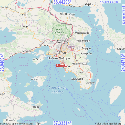
Ellinikó GPS coordinates[2]
37° 53' 24.468" North, 23° 44' 38.616" East
| Map corner | latitude | longitude |
|---|---|---|
| Upper-left | 38.44293°, | 23.04094° |
| Center: | 37.89013°, | 23.74406° |
| Lower-right: | 37.33314°, | 24.44719° |
| Map W x H: | 123.4×123.4 km | = 76.7×76.7mi |
| max Lat: | 41.72048° ⇑78.1% North |
| Ellinikó: | 37.89013° |
| min Lat: | ⇓21.9% South 34.8346° |
| min Long | Ellinikó | max Long |
| 19.40494° | 23.74406° | 29.59361° |
| W 71.2%⇐ | ⇒28.8% E |
Elevation
Elevation of Ellinikó is 52 m = 171 ft, and this is 116.9 m = 384 ft below average elevation for this country.
| Max E: |
1439 m = 4721 ft | 59.2% |
| Avg. | 168.9 m = 554 ft | |
| Ellinikó | 52 m = 171 ft | |
Min E: |
0 m = 0 ft | 40.8% |
See also: Greece elevation on elevation.city.
Geographical zone
Ellinikó is located in North temperate zone (between Tropic of Cancer and the Arctic Circle). Distance of this Northern Tropic circle is 1607.1 km =998.6 mi to South.| Distance of | km | miles | from Ellinikó |
|---|---|---|---|
| North Pole | 5794.1 | 3600.3 | to North |
| Arctic Circle | 3188.2 | 1981.1 | to North |
| Tropic Cancer | 1607.1 | 998.6 | to South |
| Equator | 4213 | 2617.8 | to South |


Nearby cities:
15 places around Ellinikó: (largest is in red/bold)
• Agios Dimitrios
4.9 km =3 mi,  348°
348°
• Argyroúpoli
1.8 km =1.1 mi,  17°
17°
• Dhafní
6.7 km =4.2 mi, 352°
• Glyfáda
3.3 km =2.1 mi,  157°
157°
• Ilioúpoli
5 km =3.1 mi, 24°
• Kaisarianí
8.4 km =5.2 mi,  12°
12°
• Kallithéa
7.7 km =4.8 mi,  329°
329°
• Moskháton
8.6 km =5.3 mi,  318°
318°
• Néa Smýrni
6.6 km =4.1 mi,  336°
336°
• Palaió Fáliro
5.7 km =3.5 mi, 318°
• Voúla
6 km =3.7 mi,  151°
151°
• Vári
8.2 km =5.1 mi,  140°
140°
• Výronas
7.9 km =4.9 mi, 5°
• Ymittos
7.1 km =4.4 mi,  3°
3°
• Álimos
2.9 km =1.8 mi, 321°
Sources, notices
• [Note1] Compared only with cities in Greece existing in our database
• [Src1] Map data: © OpenStreetMap contributors (CC-BY-SA)
• [Src2] Other city data from geonames.org with taken over terms of usage.
• [Src3] Geographical zone / Annual Mean Temperature by Robert A. Rohde @ Wikipedia
