Glyfáda geodata
Glyfáda (Attica) is a seat of a third-order administrative division; located in Greece in Europe/Athens (GMT+3) time zone. With population of 87,305 people, there are 11 cities with bigger population in this country. Compared to other cities in Greece, 78.4% of cities are located further ↑North; 71.8% of cities are located further ←West and 74.9% of cities have higher elevation than Glyfáda. Note1


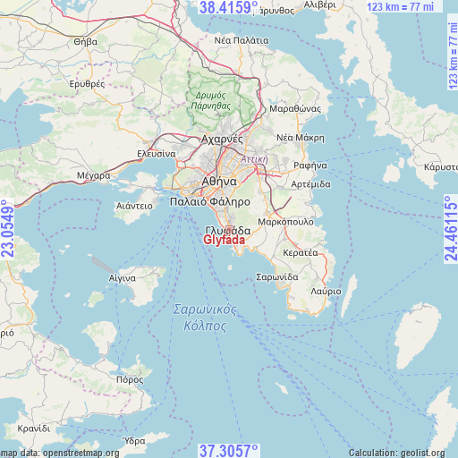
Glyfáda GPS coordinates[2]
37° 51' 46.404" North, 23° 45' 28.872" East
| Map corner | latitude | longitude |
|---|---|---|
| Upper-left | 38.4159°, | 23.0549° |
| Center: | 37.86289°, | 23.75802° |
| Lower-right: | 37.3057°, | 24.46115° |
| Map W x H: | 123.4×123.4 km | = 76.7×76.7mi |
| max Lat: | 41.72048° ⇑78.4% North |
| Glyfáda: | 37.86289° |
| min Lat: | ⇓21.6% South 34.8346° |
| min Long | Glyfáda | max Long |
| 19.40494° | 23.75802° | 29.59361° |
| W 71.8%⇐ | ⇒28.2% E |
Elevation
Elevation of Glyfáda is 24 m = 79 ft, and this is 144.9 m = 475 ft below average elevation for this country.
| Max E: |
1439 m = 4721 ft | 74.9% |
| Avg. | 168.9 m = 554 ft | |
| Glyfáda | 24 m = 79 ft | |
Min E: |
0 m = 0 ft | 25.1% |
See also: Glyfáda elevation on elevation.city.
Geographical zone
Glyfáda is located in North temperate zone (between Tropic of Cancer and the Arctic Circle). Distance of this Northern Tropic circle is 1604 km =996.7 mi to South.| Distance of | km | miles | from Glyfáda |
|---|---|---|---|
| North Pole | 5797.1 | 3602.1 | to North |
| Arctic Circle | 3191.2 | 1982.9 | to North |
| Tropic Cancer | 1604 | 996.7 | to South |
| Equator | 4210 | 2616 | to South |


Nearby cities:
15 places around Glyfáda: (largest is in red/bold)
• Agios Dimitrios
8.1 km =5 mi,  344°
344°
• Agía Marína
8.9 km =5.5 mi,  121°
121°
• Argyroúpoli
4.8 km =3 mi,  351°
351°
• Dhafní
9.9 km =6.2 mi, 347°
• Ellinikó
3.3 km =2.1 mi, 337°
• Ilioúpoli
7.7 km =4.8 mi,  6°
6°
• Koropí
10.8 km =6.7 mi,  68°
68°
• Kítsi
7.4 km =4.6 mi,  99°
99°
• Néa Smýrni
9.9 km =6.2 mi, 337°
• Palaió Fáliro
8.8 km =5.5 mi,  325°
325°
• Vouliagméni
5.7 km =3.5 mi,  161°
161°
• Voúla
2.8 km =1.7 mi,  144°
144°
• Vári
5.2 km =3.2 mi,  129°
129°
• Ymittos
10.1 km =6.3 mi,  355°
355°
• Álimos
6.1 km =3.8 mi, 330°
Sources, notices
• [Note1] Compared only with cities in Greece existing in our database
• [Src1] Map data: © OpenStreetMap contributors (CC-BY-SA)
• [Src2] Other city data from geonames.org with taken over terms of usage.
• [Src3] Geographical zone / Annual Mean Temperature by Robert A. Rohde @ Wikipedia
